IMAGES TAKEN NEAR TO
Napier Road, POOLE, BH15 4NB
Introduction
This page details the photographs taken nearby to Napier Road, BH15 4NB by members of the Geograph project.
The Geograph project started in 2005 with the aim of publishing, organising and preserving representative images for every square kilometre of Great Britain, Ireland and the Isle of Man.

There are currently over 7.5m images from over14,400 individuals and you can help contribute to the project by visiting https://www.geograph.org.uk
Image Map
Images are licensed for reuse under creativecommons.org/licenses/by-sa/2.0
Notes
- Clicking on the map will re-center to the selected point.
- The higher the marker number, the further away the image location is from the centre of the postcode.
Image Listing (20 Images Found)
Images are licensed for reuse under creativecommons.org/licenses/by-sa/2.0
Image
Details
Distance
1
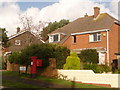
Hamworthy: postbox № BH15 248, Napier Road
An Elizabeth II-reign postbox, emptied finally at 5:30pm on weekdays and at 12:30pm on Saturdays.
Image: © Chris Downer
Taken: 15 Nov 2009
0.08 miles
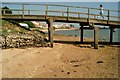
2
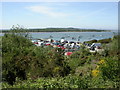
Lake, view
As seen from the viewpoint off Lake Drive; looking down to Wareham Channel, with Lake Pier to the left, and Gold Point, Arne, in the distance.
Image: © Mike Faherty
Taken: 23 May 2010
0.14 miles
3
Ham Common, pond
Pond on the site of old ball-clay workings; extraction finished in the 1920s.
Image: © Mike Faherty
Taken: 31 May 2010
0.15 miles
4
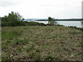
Ham Common, scrub clearance
Small areas of gorse scrub have been cleared to allow the regeneration of heathland. In the distance, Arne, across Wareham Channel.
Image: © Mike Faherty
Taken: 31 May 2010
0.18 miles
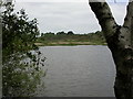
5
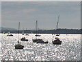
Wareham Channel
A view from Poole marina across Wareham Channel
Image: © Chris Collard
Taken: 23 Aug 2003
0.18 miles

8
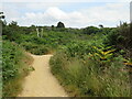
Paths at Ham Common, Poole
A junction of paths at Ham Common, on the edge of Poole Harbour.
Image: © Malc McDonald
Taken: 19 Jun 2023
0.23 miles
10
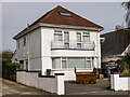
RAF Hamworthy - former WW2 control tower
The former RAF Hamworthy control tower has been converted postwar into a residential property that has recently been sold, having been on the market for £700.000. Viewed from the Royal Marines Amphibious Training Unit.
Image
Image: © Mike Searle
Taken: 1 Apr 2021
0.23 miles