IMAGES TAKEN NEAR TO
Corporation Road, BOURNEMOUTH, BH1 4SJ
Introduction
This page details the photographs taken nearby to Corporation Road, BH1 4SJ by members of the Geograph project.
The Geograph project started in 2005 with the aim of publishing, organising and preserving representative images for every square kilometre of Great Britain, Ireland and the Isle of Man.

There are currently over 7.5m images from over14,400 individuals and you can help contribute to the project by visiting https://www.geograph.org.uk
Image Map
Images are licensed for reuse under creativecommons.org/licenses/by-sa/2.0
Notes
- Clicking on the map will re-center to the selected point.
- The higher the marker number, the further away the image location is from the centre of the postcode.
Image Listing (288 Images Found)
Images are licensed for reuse under creativecommons.org/licenses/by-sa/2.0
Image
Details
Distance
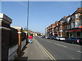
1
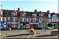
Shops on Holdenhurst Road, Bournemouth
'Simply Pleasure' is a sex shop.
Image: © Robin Webster
Taken: 25 Nov 2016
0.02 miles
2
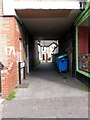
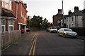
Springbourne: footpath D09 to Corporation Road
This short public footpath - 19m in length - leads from the main Holdenhurst Road to Corporation Road, a short cul-de-sac which runs parallel behind these shops. The path, named Corporation Walk in recent years, takes a tunnel for the first half of its journey.
See Image for a view this way from the other end.
Image: © Chris Downer
Taken: 1 Jul 2016
0.02 miles
3
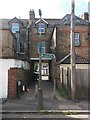
Springbourne: footpath D09 to Holdenhurst Road
A public footpath leading to the main Holdenhurst Road from Corporation Road, a short cul-de-sac behind the shops, as we see here.
See Image for the view from the other end.
Image: © Chris Downer
Taken: 1 Jul 2016
0.02 miles
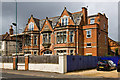
6
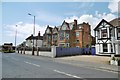
Springbourne, former drill hall
On Holdenhurst Road; according to an inscription on the stonework, once Headquarters of 5th/7th Battalion, Hampshire Regiment (most of Bournemouth is in the historic county of Hants.).
Image: © Mike Faherty
Taken: 21 May 2015
0.03 miles
7
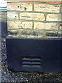
Benchmark on Portchester Health Centre Dental Practice
Ordnance Survey cut mark benchmark described on the Bench Mark Database at http://www.bench-marks.org.uk/bm36375
Image: © Roger Templeman
Taken: 21 Dec 2010
0.04 miles
8
Bournemouth: former Drill Hall, 177 Holdenhurst Road
Former Headquarters and Drill Hall of the 5th/7th Battalion Hampshire Regiment (Territorial Force Depot), at 177 Holdenhurst Road.
Image: © Mike Searle
Taken: 10 May 2014
0.04 miles
10
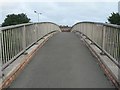
Springbourne: glimpse of rooftops
A view of the rooftops of Springbourne from a footbridge crossing the main road. The footbridge is public footpath C21.
See:
Image for a view of the path as it ascends the eastern spiral ramp;
Image for a view of the spiral path as it reaches ground level on the western side; and
Image for a view of the western spiral from outwith the bridge.
Image for a view of the
Image: © Chris Downer
Taken: 10 Jul 2008
0.04 miles