IMAGES TAKEN NEAR TO
Windham Road, BOURNEMOUTH, BH1 4RQ
Introduction
This page details the photographs taken nearby to Windham Road, BH1 4RQ by members of the Geograph project.
The Geograph project started in 2005 with the aim of publishing, organising and preserving representative images for every square kilometre of Great Britain, Ireland and the Isle of Man.

There are currently over 7.5m images from over14,400 individuals and you can help contribute to the project by visiting https://www.geograph.org.uk
Image Map
Images are licensed for reuse under creativecommons.org/licenses/by-sa/2.0
Notes
- Clicking on the map will re-center to the selected point.
- The higher the marker number, the further away the image location is from the centre of the postcode.
Image Listing (163 Images Found)
Images are licensed for reuse under creativecommons.org/licenses/by-sa/2.0
Image
Details
Distance
4
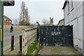
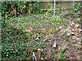
WWII defences in the environs of Bournemouth & Christchurch: Cleveland Rd Pillbox (1)
-
Pillbox: EDoB ID: e44901
The railway from Christchurch to Bournemouth was a local stop line that saw several pillboxes built trackside along its length. Two pillboxes were known to have been built into the embankment either side of the north end of the Cleveland Road railway bridge in Bournemouth. Some recent and vigorous clearance of trees and vegetation here has now revealed for the first time the one on the east side, whose concrete roof can just be seen (arrowed). There is no sign of the other one on the west side.
Update 10 Oct 2019: a business owner has since informed me that the pillbox on the west side of the bridge is very much extant, and has invited me to photograph it.
Image
Image: © Mike Searle
Taken: 10 Apr 2018
0.05 miles
5
WWII defences in the environs of Bournemouth & Christchurch: Cleveland Rd Pillbox (2)
-
Pillbox: EDoB ID: e44901
The concrete roofline of the pillbox can be seen in this close view, as well as an opening at the west end that may have been the entrance. Like its companion on the other side of the bridge, it was built into the railway embankment, although certainly not to this extent, where it has now become almost completely buried.
Image
Image: © Mike Searle
Taken: 10 Apr 2018
0.05 miles
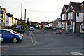
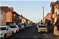
7

Cleveland Road bridge
Carrying road traffic over the South West main line.
Image: © Neil Owen
Taken: 7 Sep 2021
0.06 miles
9
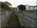
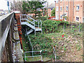
Springbourne: damaged fence on footpath J01
Looking along a public footpath running from Spring Road to Windham Road (ahead), the next parallel street. Meanwhile, alongside it runs a driveway to flats built as infill in what was originally back gardens - the concrete fence separating the path from the drive is damaged but the panel is still here.
See Image for the view along the path from Windham Road ahead, and Image for the next photo on the path behind.
Image: © Chris Downer
Taken: 14 Feb 2017
0.06 miles
10
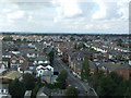
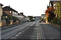
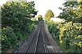
Cleveland Road from St Clements Church Tower
Image: © Wilf Vernon
Taken: 13 Sep 2008
0.06 miles