IMAGES TAKEN NEAR TO
Palmerston Road, BOURNEMOUTH, BH1 4HS
Introduction
This page details the photographs taken nearby to Palmerston Road, BH1 4HS by members of the Geograph project.
The Geograph project started in 2005 with the aim of publishing, organising and preserving representative images for every square kilometre of Great Britain, Ireland and the Isle of Man.

There are currently over 7.5m images from over14,400 individuals and you can help contribute to the project by visiting https://www.geograph.org.uk
Image Map
Images are licensed for reuse under creativecommons.org/licenses/by-sa/2.0
Notes
- Clicking on the map will re-center to the selected point.
- The higher the marker number, the further away the image location is from the centre of the postcode.
Image Listing (249 Images Found)
Images are licensed for reuse under creativecommons.org/licenses/by-sa/2.0
Image
Details
Distance
1
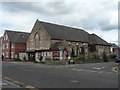
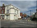
Boscombe: Baptist church
Boscombe's Baptist church is in Palmerston Road, on the corner of Gladstone Road West.
Image: © Chris Downer
Taken: 12 Jul 2008
0.01 miles
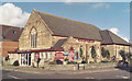
3
Boscombe Baptist Church
The Baptist Church in Boscombe, near Bournemouth
Image: © Malc McDonald
Taken: 17 Aug 2021
0.03 miles
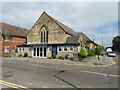
4
Bournemouth : Boscombe - Palmerston Road
Image: © Lewis Clarke
Taken: 22 Apr 2009
0.03 miles
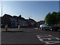
5
Shelley Road, Boscombe
Shelley Road in Boscombe, near Bournemouth. "No entry" signs indicate that this is a one-way street.
Image: © Malc McDonald
Taken: 17 Aug 2021
0.03 miles
6
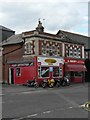
Boscombe: former monumentalists
The stonework along the top of this building, now a motorcycle dealership and butcher, reads "Samuel J. Alsford & Sons" between the words 'cemetery' and 'masons'. The word 'monumentalists' is on the left-facing end, in a poor state of repair – the stonemasons would no doubt have been quick to remedy this if they still occupied the premises!
Image: © Chris Downer
Taken: 12 Jul 2008
0.04 miles
7
Boscombe: a little bit of then & now - top of Gladstone Rd West c.1988 (4)
Site clearance in operation preparatory to the Boscombe Sovereign Centre development, a key component of the controversial Boscombe Plan of the late 1980s. The view is from the junction of Gladstone Road West and Palmerston Road towards Haviland Road West.
The same view today: Image
NEXT: Image
Image: © Mike Searle
Taken: Unknown
0.05 miles
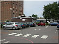
8
Boscombe: a little bit of then & now - top of Gladstone Rd West in 2013
The junction of Gladstone Road West and Palmerston Road, a view for comparison purposes with that taken in c.1988. Image]
Image: © Mike Searle
Taken: 5 Mar 2013
0.05 miles
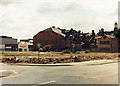
9
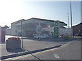
Bournemouth : Boscombe - BP Petrol Station
Image: © Lewis Clarke
Taken: 22 Apr 2009
0.06 miles
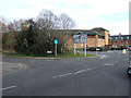
10
Boscombe & Springbourne Health Centre
Brand new centre (opened today), in the shadows of Image and next to NHS offices. A walk-in centre, open 12 hours a day and 365 days a year. http://www.nwic.org.uk/
Image: © Mike Faherty
Taken: 1 Jul 2009
0.07 miles