IMAGES TAKEN NEAR TO
Shelley Road, BOURNEMOUTH, BH1 4GZ
Introduction
This page details the photographs taken nearby to Shelley Road, BH1 4GZ by members of the Geograph project.
The Geograph project started in 2005 with the aim of publishing, organising and preserving representative images for every square kilometre of Great Britain, Ireland and the Isle of Man.

There are currently over 7.5m images from over14,400 individuals and you can help contribute to the project by visiting https://www.geograph.org.uk
Image Map
Images are licensed for reuse under creativecommons.org/licenses/by-sa/2.0
Notes
- Clicking on the map will re-center to the selected point.
- The higher the marker number, the further away the image location is from the centre of the postcode.
Image Listing (240 Images Found)
Images are licensed for reuse under creativecommons.org/licenses/by-sa/2.0
Image
Details
Distance
1
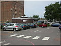
Boscombe & Springbourne Health Centre
Brand new centre (opened today), in the shadows of Image and next to NHS offices. A walk-in centre, open 12 hours a day and 365 days a year. http://www.nwic.org.uk/
Image: © Mike Faherty
Taken: 1 Jul 2009
0.04 miles
2
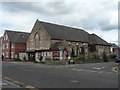
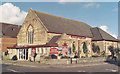
Boscombe: Baptist church
Boscombe's Baptist church is in Palmerston Road, on the corner of Gladstone Road West.
Image: © Chris Downer
Taken: 12 Jul 2008
0.05 miles
3
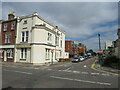
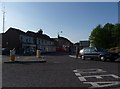
Shelley Road, Boscombe
Shelley Road in Boscombe, near Bournemouth. "No entry" signs indicate that this is a one-way street.
Image: © Malc McDonald
Taken: 17 Aug 2021
0.06 miles
4
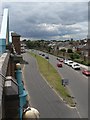
Boscombe: Centenary Way
This road was put in when the main Christchurch Road in central Boscombe was pedestrianised, and the Sovereign shopping centre built, in 1990. It is named after the fact that that year marked the 100th anniversary of Bournemouth becoming a town. Here, we are looking from the top level of the Sovereign Centre car park.
On the right, we see a wall shielding the heavy traffic from Gladstone Road West, whose southern properties were sacrificed for this new-look Boscombe centre.
Image: © Chris Downer
Taken: 12 Jul 2008
0.06 miles
6

Boscombe, water tower
At the junction of Palmerston & Tower Roads; now converted to flats.
Image: © Mike Faherty
Taken: 1 Jul 2009
0.07 miles
7
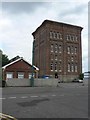
Boscombe: the water tower
This water tower is close to the site of the former Boscombe Hospital, which it used to serve, and is now on grounds that are the estate office of the local NHS Trust.
Image: © Chris Downer
Taken: 12 Jul 2008
0.07 miles
8
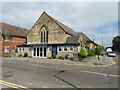
Boscombe Baptist Church
The Baptist Church in Boscombe, near Bournemouth
Image: © Malc McDonald
Taken: 17 Aug 2021
0.07 miles
9
Bournemouth : Boscombe - Palmerston Road
Image: © Lewis Clarke
Taken: 22 Apr 2009
0.08 miles
10
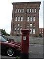
Boscombe: postbox № BH1 36, Palmerston Road
Image: © Chris Downer
Taken: 12 Jul 2008
0.08 miles