IMAGES TAKEN NEAR TO
Borthwick Lane, BOURNEMOUTH, BH1 4EY
Introduction
This page details the photographs taken nearby to Borthwick Lane, BH1 4EY by members of the Geograph project.
The Geograph project started in 2005 with the aim of publishing, organising and preserving representative images for every square kilometre of Great Britain, Ireland and the Isle of Man.

There are currently over 7.5m images from over14,400 individuals and you can help contribute to the project by visiting https://www.geograph.org.uk
Image Map
Images are licensed for reuse under creativecommons.org/licenses/by-sa/2.0
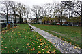
Notes
- Clicking on the map will re-center to the selected point.
- The higher the marker number, the further away the image location is from the centre of the postcode.
Image Listing (124 Images Found)
Images are licensed for reuse under creativecommons.org/licenses/by-sa/2.0
Image
Details
Distance
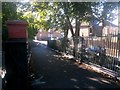
1
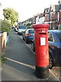
Boscombe: postbox № BH1 110, Walpole Road
Looking south along Walpole Road, past this George VI-reign postbox as it catches the evening sun just before 8.
Image: © Chris Downer
Taken: 13 Jul 2008
0.01 miles
3
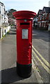
George VI postbox on Walpole Road
Postbox No. BH1 110.
Image: © JThomas
Taken: 21 Mar 2022
0.03 miles
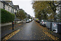
4
Houses on Walpole Road
Showing position of Postbox No. BH1 110.
Image: © JThomas
Taken: 21 Mar 2022
0.03 miles
5
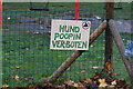
Hund Poopin Ver-Boten
Sign in Churchill Gardens, Boscombe.
Image: © Ian S
Taken: 15 Nov 2022
0.06 miles
6
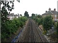
Boscombe: the railway
Looking west along the railway line north of the centre of Boscombe, from the South Road footbridge.
Image: © Chris Downer
Taken: 12 Jul 2008
0.06 miles
7
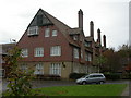
Boscombe, House of Bethany
In St. Clement's Gardens, hemmed in between school and modern housing; former convent and orphanage, founded by the Sisters of Bethany in 1872. Closed in 1986, and converted to flats. http://www.sistersofbethany.org.uk/history.htm Listed by English Heritage, http://www.sistersofbethany.org.uk/history.htm
Image: © Mike Faherty
Taken: 3 Nov 2009
0.07 miles
8
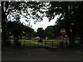
Boscombe: Churchill Gardens
Churchill Gardens is a squareish park bounded by Walpole Road to the west, Borthwick Road to the south and Churchill Road to the north and east.
Image: © Chris Downer
Taken: 12 Jul 2008
0.08 miles
9
Turf Zone "Churchill Turf"
In Churchill Gardens, Boscombe.
Image: © Ian S
Taken: 15 Nov 2022
0.08 miles
10
Boscombe: footbridge ramp down to South Road
This footbridge crosses the railway from South Road, where it turns into Curzon Road (ahead), to a similar layout in Palmerston and St. Clement's Roads on the south side.
The footbridge is public footpath number F05 / J02 - the railway line seems to be the boundary between the numbering prefixes (I think based on ward boundaries) and this right of way is numbered in both zones.
See Image for the view up the ramp towards us and Image for a view to our left on the top of the bridge.
Image: © Chris Downer
Taken: 9 Oct 2016
0.08 miles