IMAGES TAKEN NEAR TO
Elgin Road, POOLE, BH14 8PR
Introduction
This page details the photographs taken nearby to Elgin Road, BH14 8PR by members of the Geograph project.
The Geograph project started in 2005 with the aim of publishing, organising and preserving representative images for every square kilometre of Great Britain, Ireland and the Isle of Man.

There are currently over 7.5m images from over14,400 individuals and you can help contribute to the project by visiting https://www.geograph.org.uk
Image Map
Images are licensed for reuse under creativecommons.org/licenses/by-sa/2.0
Notes
- Clicking on the map will re-center to the selected point.
- The higher the marker number, the further away the image location is from the centre of the postcode.
Image Listing (20 Images Found)
Images are licensed for reuse under creativecommons.org/licenses/by-sa/2.0
Image
Details
Distance
1
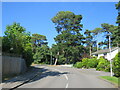
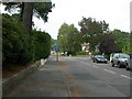
Broadwater Avenue, Parkstone, near Poole
Broadwater Avenue is a residential road in Parkstone, a suburb of Poole. This road is on the route of National Cycle Network route 25.
Image: © Malc McDonald
Taken: 25 Aug 2021
0.04 miles
2
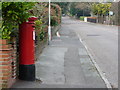
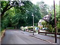
Parkstone: postbox № BH14 69, Compton Avenue
A cat contemplates jumping onto a low wall a little farther up the road, though in the end it disappeared up a driveway at ground level. The George V-reign postbox is emptied finally at 5:30pm on weekdays and at 11:45am on Saturdays.
Image: © Chris Downer
Taken: 10 Jan 2009
0.08 miles
3
Potters Way, Parkstone, Poole
Potters Way is a residential road in Parkstone, a suburb of Poole.
Image: © Malc McDonald
Taken: 25 Aug 2021
0.09 miles
4
Sandecotes Road, Parkstone, near Poole
Sandecotes Road in Parkstone, a suburb of Poole. To the left, a short cycle path enables cyclists and pedestrians to cut through to Alton Road East. The path is on the route of National Cycle Network route 25.
Image: © Malc McDonald
Taken: 25 Aug 2021
0.09 miles
5
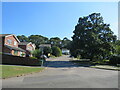
Parkstone, roundabout
Suburban roundabout at the junction of Compton Avenue, Compton Drive (to the left) & Links Road (to the right).
Image: © Mike Faherty
Taken: 19 Sep 2009
0.09 miles
6
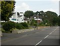
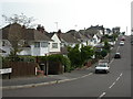
Parkstone, Alton Road
A typical scene of housing in the south-eastern side of Parkstone; larger detached houses, with denser more modern infill.
Image: © Mike Faherty
Taken: 19 Sep 2009
0.10 miles
7
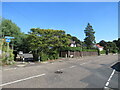
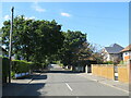
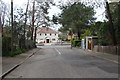
Elgin Rd Poole
View east near the end of this cul-de-sac. Elgin Rd is a long residential road that runs east from Sandbanks Rd In Lower Parkstone.Although shown on the map as continuing east past this point it can be seen that the road terminates at a metal barrier. Beyond the barrier there is little more than a muddy track through the woods.
Image: © Nigel Mykura
Taken: 13 Jul 2010
0.12 miles
8
Gleneagles Avenue, near Poole
Gleneagles Avenue is a minor residential road near Poole.
Image: © Malc McDonald
Taken: 25 Aug 2021
0.13 miles
9
Parkstone, Blake Hill Avenue
A variety of housing, from the 1920s when the estate was originally built, to more modern.
Image: © Mike Faherty
Taken: 19 Sep 2009
0.14 miles
10
Durlston Road at junction with Alton Road
Image: © Ruth Sharville
Taken: 16 Apr 2009
0.16 miles