IMAGES TAKEN NEAR TO
Knyveton Road, BOURNEMOUTH, BH1 3QS
Introduction
This page details the photographs taken nearby to Knyveton Road, BH1 3QS by members of the Geograph project.
The Geograph project started in 2005 with the aim of publishing, organising and preserving representative images for every square kilometre of Great Britain, Ireland and the Isle of Man.

There are currently over 7.5m images from over14,400 individuals and you can help contribute to the project by visiting https://www.geograph.org.uk
Image Map
Images are licensed for reuse under creativecommons.org/licenses/by-sa/2.0
Notes
- Clicking on the map will re-center to the selected point.
- The higher the marker number, the further away the image location is from the centre of the postcode.
Image Listing (196 Images Found)
Images are licensed for reuse under creativecommons.org/licenses/by-sa/2.0
Image
Details
Distance
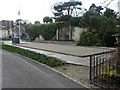
2
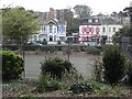
Bournemouth: Knyveton Gardens and Frances Road
Looking across the tennis courts of Image at two colourful properties in Frances Road.
Image: © Chris Downer
Taken: 19 Mar 2008
0.07 miles
3
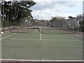
Bournemouth: Knyveton Gardens tennis courts
Looking along the line of tennis courts in Image
Image: © Chris Downer
Taken: 19 Mar 2008
0.07 miles
4
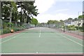
Knyveton Gardens, tennis courts
Operated by http://saintsebastiantennis.co.uk/
Image: © Mike Faherty
Taken: 21 May 2015
0.07 miles
5
East Cliff, Knyveton Gardens
A linear park, partially laid out to trees and plants; also with café, tennis courts and bowling club.
Image: © Mike Faherty
Taken: 21 May 2015
0.08 miles
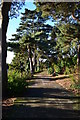
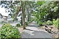
6
Bournemouth: Knyveton Gardens path
The main path through Image, alongside the tennis courts.
Image: © Chris Downer
Taken: 19 Mar 2008
0.08 miles
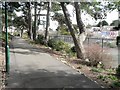
7
Bournemouth: Knyveton Gardens
The noticeboard at the entrance to Knyveton Gardens (pronounced "Nivverton") is very informative about their history.
They were leased from the trustees of the late W.I. Trehearne for an annual rent of £100, on 21 July 1885, for a 99-year term. The original bowling green had been established by 1912 and it was upgraded to a full size green after the First World War. The freehold was sold to the Council for £1,000 on 15 June 1922. The new pavilion was erected on further land abutting Southcote Road purchased on 7 March 1929. The pavilion was used by ARP Wardens in the Second World War. The current pavilion dates from the 1990s and replaced the one mentioned above; at this time the sensory garden was added and in 1999 the petanque area was installed.
Image: © Chris Downer
Taken: 19 Mar 2008
0.08 miles
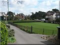
8

A green rainbow
Knyveton Gardens Bowling Club is keeping the playing surfaces in tip-top condition during the summer. A rainbow accompanies the spray.
Image: © Neil Owen
Taken: 7 Sep 2021
0.08 miles
10
Bournemouth: Knyveton Gardens petanque area
I'm not sure of the correct term for the playing surface of petanque – is it rink or pitch or simply ground? – but whatever, this was installed in Image in 1999.
Image: © Chris Downer
Taken: 19 Mar 2008
0.09 miles