IMAGES TAKEN NEAR TO
Manor Road, BOURNEMOUTH, BH1 3JD
Introduction
This page details the photographs taken nearby to Manor Road, BH1 3JD by members of the Geograph project.
The Geograph project started in 2005 with the aim of publishing, organising and preserving representative images for every square kilometre of Great Britain, Ireland and the Isle of Man.

There are currently over 7.5m images from over14,400 individuals and you can help contribute to the project by visiting https://www.geograph.org.uk
Image Map
Images are licensed for reuse under creativecommons.org/licenses/by-sa/2.0
Notes
- Clicking on the map will re-center to the selected point.
- The higher the marker number, the further away the image location is from the centre of the postcode.
Image Listing (200 Images Found)
Images are licensed for reuse under creativecommons.org/licenses/by-sa/2.0
Image
Details
Distance
1
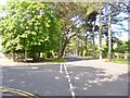
East Cliff, Manor Road
From Christchurch Road back to Christchurch Road at Landsdown, but via a route closer to the sea. The road is pine tree-lined where it is flat, and largely populated by hotels. To the left, a side arm of the road, to East Overcliff Car Park.
Image: © Mike Faherty
Taken: 12 Jun 2014
0.03 miles
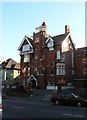
2

East Cliff Lodge
Originally home to a Captain Carson, the extravagantly styled building became the East Cliff Towers Hotel during the twentieth century before being converted into private residences.
Image: © Neil Owen
Taken: 7 Sep 2021
0.03 miles
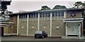
3

Bournemouth: Reform Synagogue
Bournemouth Reform Synagogue, at 53 Christschurch Road, used to be called the New Synagogue and occupies a rather unassuming position, partly concealed by trees.
Image: © Chris Downer
Taken: 1 Jan 2008
0.04 miles
5
Bournemouth: East Cliff Lodge
An intriguing former guest house on Christchurch Road, now apartments.
Image: © Chris Downer
Taken: 23 Nov 2007
0.05 miles
6
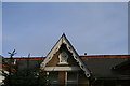
Diagonal datestone
Atop a house on Manor Road, Boscombe.
Image: © David Lally
Taken: 16 May 2010
0.05 miles
7
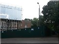
Boscombe: footpath D02 and the Cliff End Hotel
The state of the derelict old hotel has gradually worsened since I photographed it on the first day of 2009 (Image) and it has recently been shored up with scaffolding in a bid to somehow regenerate it.
Meanwhile, alongside is a public footpath leading down to Boscombe Chine Gardens. See Image for the next photo on the path, and links to further pictures along the route.
Image: © Chris Downer
Taken: 30 Sep 2016
0.08 miles
8
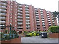
Green Park apartment block, Manor Road, Boscombe
Image: © David Smith
Taken: 29 Mar 2017
0.08 miles
9
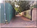
Boscombe: footpath D02 from Manor Road
A lady walks along this public footpath to Boscombe Chine Gardens - the left-hand side of the footpath is bounded by a building-site fence, being that of the derelict Cliff End Hotel (see 2009 photo Image).
See Image for the wider view from behind us, and Image for the next photo on the path, with links to further pictures along the route.
Image: © Chris Downer
Taken: 30 Sep 2016
0.08 miles
10
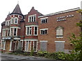
The derelict Cliff End Hotel, Boscombe, Bournemouth
Originally built for the jeweller H. Samuel in 1887 it became a hotel which closed in 2002. Subsequently it had lain derelict and was ravaged by a fire in the last days of 2012. Beneath the hotel's name can be seen a large sundial, which bears the splendid inscription 'We Only Count The Sunny Hours'
Image: © Jonathan Hutchins
Taken: 6 May 2010
0.09 miles