IMAGES TAKEN NEAR TO
Christchurch Road, BOURNEMOUTH, BH1 3FF
Introduction
This page details the photographs taken nearby to Christchurch Road, BH1 3FF by members of the Geograph project.
The Geograph project started in 2005 with the aim of publishing, organising and preserving representative images for every square kilometre of Great Britain, Ireland and the Isle of Man.

There are currently over 7.5m images from over14,400 individuals and you can help contribute to the project by visiting https://www.geograph.org.uk
Image Map
Images are licensed for reuse under creativecommons.org/licenses/by-sa/2.0
Notes
- Clicking on the map will re-center to the selected point.
- The higher the marker number, the further away the image location is from the centre of the postcode.
Image Listing (112 Images Found)
Images are licensed for reuse under creativecommons.org/licenses/by-sa/2.0
Image
Details
Distance
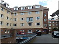
1
Bournemouth, Lyndon Court
Pub on Christchurch Road, with adjacent motel. Internally, L-shaped bar with drinking & eating areas left, front, right; use of stone, brick and light woods. Games machines, TV, background music. Cask ales on offer at my visit: Ringwood Best, Boondoggle; Shepherd Neame Spitfire.
Image: © Mike Faherty
Taken: 25 Jun 2011
0.05 miles
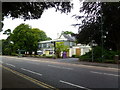
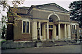
2
Teaching a different course
The former First Church of Christ, Scientist, closed in around 2014 and has since been an English education establishment. It was following the movement first started in America in the early 1900s.
It was built in 1926 to designs by W.J. Dacombe of Bournemouth in the English tradition and without a spire, with an entrance portico in the Ionic Order. Work was carried out by Burt and Vick of Poole.
Image: © Neil Owen
Taken: 22 Jun 2022
0.05 miles
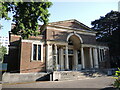
5

Bournemouth: First Church of Christ Scientist
Situated on Christchurch Road on the East Cliff.
Image: © Chris Downer
Taken: 1 Jan 2008
0.05 miles
6
Rear of Bournemouth Travelodge, Boscombe
Image: © Jonathan Hutchins
Taken: 4 May 2010
0.07 miles
7
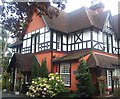
Langtry Manor Hotel
The house was built in 1877 by the Prince of Wales (later Edward VII) for his mistress Lillie Langtry.
Image: © Jonathan Hutchins
Taken: 10 Sep 2011
0.07 miles
9
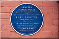
Bournemouth Blue Plaques: No. 21 - Langtry Manor Hotel
The plaque commemorates the hotel in Derby Road as being (in modern parlance) the former love-nest of Edward Prince of Wales, and his mistress the actress, socialite and beauty, Lillie Langtry, the "Jersey Lily" (1853 - 1929).
Image
Image
Image: © Mike Searle
Taken: 9 Apr 2015
0.08 miles
10
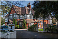
Bournemouth - Langtry Manor Hotel
This popular hotel in Bournemouth's Derby Road capitalises on its association with Edwardian royalty when it was known as the "Red House". It was built in 1877 by Edward, Prince of Wales (later King Edward VII) for his mistress Lillie Langtry (1853 - 1929).
Image
Image: © Mike Searle
Taken: 9 Apr 2015
0.08 miles