IMAGES TAKEN NEAR TO
Southcote Road, BOURNEMOUTH, BH1 3BL
Introduction
This page details the photographs taken nearby to Southcote Road, BH1 3BL by members of the Geograph project.
The Geograph project started in 2005 with the aim of publishing, organising and preserving representative images for every square kilometre of Great Britain, Ireland and the Isle of Man.

There are currently over 7.5m images from over14,400 individuals and you can help contribute to the project by visiting https://www.geograph.org.uk
Image Map
Images are licensed for reuse under creativecommons.org/licenses/by-sa/2.0
Notes
- Clicking on the map will re-center to the selected point.
- The higher the marker number, the further away the image location is from the centre of the postcode.
Image Listing (369 Images Found)
Images are licensed for reuse under creativecommons.org/licenses/by-sa/2.0
Image
Details
Distance
1
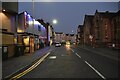
Bournemouth, Heart FM
Commercial radio station, as seen from Holdenhurst Road, though the entrance is in Southcote Road. http://www.heart.co.uk/dorset/localise/regions/
Image: © Mike Faherty
Taken: 5 Aug 2010
0.01 miles
2
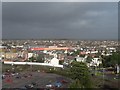
Dark skies over sunny Bournemouth
While the sun shines on the town centre of Bournemouth, the skies tell a different story of the weather in store shortly. The large red building in the centre of the picture is Image, with Image in the middle distance above left of it.
Image: © Chris Downer
Taken: 14 Jan 2008
0.01 miles
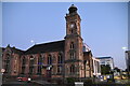
3

Bournemouth: 2CR FM
This art deco building has been the headquarters of the local radio station for at least 20 years to my knowledge. Originally known as Two Counties Radio, it is now named after its long-term colloquial abbreviation of 2CR.
Image: © Chris Downer
Taken: 17 Oct 2008
0.01 miles
4
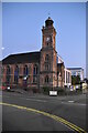
East Cliff UR Church
Grade II listed. https://historicengland.org.uk/listing/the-list/list-entry/1324771
Image: © N Chadwick
Taken: 13 Jul 2019
0.02 miles
5
East Cliff UR Church
Grade II listed. https://historicengland.org.uk/listing/the-list/list-entry/1324771
Image: © N Chadwick
Taken: 13 Jul 2019
0.02 miles
6
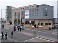
Bournemouth: Dorchester House
One of the most distinctive new buildings in the town, Dorchester House is a block of student accommodation for Bournemouth University. The 540-room block was opened for the 2012-13 academic year. Like most of the uni buildings, it is named after local towns and villages - others, for example, are Lyme Regis House, Studland House and Hurn House.
Dorchester House is built on the site of the former B&Q superstore, which took on a new life after the DIY chain vacated it as the home of a church. It was demolished in December 2008 (see Image for a comparable view taken from the same spot; today's view is slightly wider because the new building takes up a lot of the B&Q front car park).
Image: © Chris Downer
Taken: 28 Mar 2013
0.02 miles
7
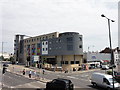
Dorchester House
Bournemouth University student accommodation block opened in 2012. To the right of this building is KTV Lan Club, a karaoke bar.
Image: © Mat Tuck
Taken: 23 Jul 2013
0.03 miles
8
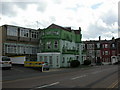
Bournemouth, flats
At the corner of Southcote and St. Swithun's Roads, notable for their garish colour scheme, and some fine masonry detail Image
Image: © Mike Faherty
Taken: 5 Aug 2010
0.03 miles
9
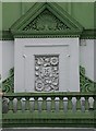
Bournemouth, flats, detail
Intricate Victorian masonry and brickwork detail at Image
Image: © Mike Faherty
Taken: 5 Aug 2010
0.03 miles