IMAGES TAKEN NEAR TO
Christchurch Road, BOURNEMOUTH, BH1 3BE
Introduction
This page details the photographs taken nearby to Christchurch Road, BH1 3BE by members of the Geograph project.
The Geograph project started in 2005 with the aim of publishing, organising and preserving representative images for every square kilometre of Great Britain, Ireland and the Isle of Man.

There are currently over 7.5m images from over14,400 individuals and you can help contribute to the project by visiting https://www.geograph.org.uk
Image Map
Images are licensed for reuse under creativecommons.org/licenses/by-sa/2.0
Notes
- Clicking on the map will re-center to the selected point.
- The higher the marker number, the further away the image location is from the centre of the postcode.
Image Listing (162 Images Found)
Images are licensed for reuse under creativecommons.org/licenses/by-sa/2.0
Image
Details
Distance
1
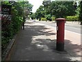
Bournemouth: postbox № BH1 2, Christchurch Road
A George V-reign postbox standing alongside the busy A35 Christchurch Road, which has a slightly damaged top.
In 2009 it was repositioned a short distance east – see Image
Image: © Chris Downer
Taken: 26 Jun 2008
0.03 miles
2
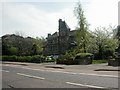
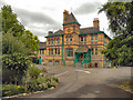
Bournemouth Natural Science Society
On Christchurch Road; a society whose aim is to "promote the study of all branches of Science and Natural History", by holding meetings, keeping extensive collections & organising field trips http://bnss.org.uk/ The building is English Heritage-listed http://www.imagesofengland.org.uk/Details/Default.aspx?id=101722&mode=adv
Image: © Mike Faherty
Taken: 21 Apr 2009
0.03 miles
3
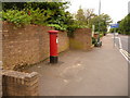
Bournemouth: repositioned postbox in Christchurch Road
About a year ago, the Image was moved to this new position, close to the Derby Road crossroads. Its original position was in the distance as we look now.
The only reason I can think of for this movement is that, after the bus lane was put in a few years ago, it was difficult for the postman to stop to empty the box without causing an obstruction – whereas now he can park just around the corner.
Image: © Chris Downer
Taken: 31 May 2010
0.04 miles
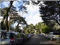
6
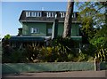
"Bassendean", 39 Christchurch Road
Bournemouth was founded in the area between the ancient towns of Christchurch and Poole, with the settlement of Lewis Tregonwell in 1810. By 1870, housing began spreading along the Christchurch Road. Number 39 is one of the few remaining from the original street. It was built in 1880. It is now a Grade II listed building.
Image: © David Dixon
Taken: 4 Aug 2010
0.08 miles
7
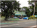
The Water Garden Hotel
Chichester Road, at the corner of Annerley Road.
Image: © David Dixon
Taken: 4 Aug 2010
0.08 miles
9
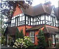
Langtry Manor Hotel
The house was built in 1877 by the Prince of Wales (later Edward VII) for his mistress Lillie Langtry.
Image: © Jonathan Hutchins
Taken: 10 Sep 2011
0.08 miles
10
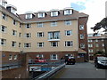
Rear of Bournemouth Travelodge, Boscombe
Image: © Jonathan Hutchins
Taken: 4 May 2010
0.09 miles