IMAGES TAKEN NEAR TO
Fir Vale Road, BOURNEMOUTH, BH1 2JG
Introduction
This page details the photographs taken nearby to Fir Vale Road, BH1 2JG by members of the Geograph project.
The Geograph project started in 2005 with the aim of publishing, organising and preserving representative images for every square kilometre of Great Britain, Ireland and the Isle of Man.

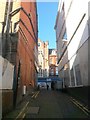
There are currently over 7.5m images from over14,400 individuals and you can help contribute to the project by visiting https://www.geograph.org.uk
Image Map
Images are licensed for reuse under creativecommons.org/licenses/by-sa/2.0
Notes
- Clicking on the map will re-center to the selected point.
- The higher the marker number, the further away the image location is from the centre of the postcode.
Image Listing (1305 Images Found)
Images are licensed for reuse under creativecommons.org/licenses/by-sa/2.0
Image
Details
Distance
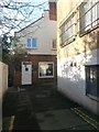
1
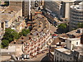
Bournemouth: looking down on St. Peter?s/Fir Vale Roads
Looking down from Image, we see a graceful curving terrace fronting onto St. Peter's Road, which disappears off to the right with Fir Vale Road continuing ahead, the most prominent tarmac visible in this picture.
For a view of the same terrace from the ground, see Image
Image: © Chris Downer
Taken: 21 Jun 2010
0.00 miles
2
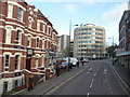
Bournemouth : St Peter's Road
St Peter's Road, which leads into Fir Vale Road here.
Image: © Lewis Clarke
Taken: 20 Nov 2009
0.01 miles
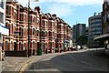
4
Bournemouth: Waterloo and Victoria Chambers
Part of an attractive line of originally offices that now house an English language school. Beyond them and, numbers 8 and 10 Fir Vale Road are attached to 28 St. Peter's Road as the terrace continues into the latter.
Seen in the distance is Image
Image: © Chris Downer
Taken: 8 Apr 2008
0.01 miles
5
Bournemouth: facing Fusion on Old Christchurch Lane
A view along this rear access driveway to shops on Old Christchurch Road (right). The route is also a public footpath, number C09.
We are just approaching the corner where the driveway turns to meet Old Christchurch Road itself; ahead is Fusion, a youth centre aimed at teenagers, possibly the only postal address in Old Christchurch Lane.
See Image for the next view on the path ahead-right, and Image for the next view behind us, with links to further pictures along the route.
Image: © Chris Downer
Taken: 13 Jan 2017
0.02 miles
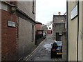
6
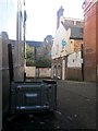
Bournemouth: beyond the underside of a microwave on Old Christchurch Lane
A view along this rear access driveway to shops on Old Christchurch Road. The route is also a public footpath, number C09.
The main carriageway of Old Christchurch Road is just behind us, and the path ahead turns left to run along the back of the shops. The building on the right is Fusion, a youth centre aimed at teenagers and possibly the only postal address in Old Christchurch Lane.
See Image for the view down here from the top of the driveway (behind us), and Image for the next view on the path ahead, with links to further pictures along the route.
Image: © Chris Downer
Taken: 13 Jan 2017
0.02 miles
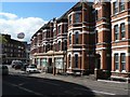
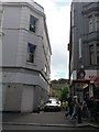
7
Bournemouth : St Peter's Road & Burlington Arcade
There is a turn in the road, and the buildings curve also.
Image: © Lewis Clarke
Taken: 20 Nov 2009
0.02 miles
8
Bournemouth: Old Christchurch Lane from Old Christchurch Road
Old Christchurch Lane is essentially a back alley providing delivery access to the shops to our left - it swings left after a few yards and runs along the back of the premises.
It also forms public footpath C09, although it isn't much of a short cut compared with continuing along the main road and turning right.
See Image] for the next view along the path ahead, with links to further photos along the route.
Image: © Chris Downer
Taken: 15 Jun 2016
0.02 miles
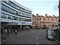
9
Bournemouth: Old Christchurch Lane approaches Old Christchurch Road
A view along this rear access driveway to shops on Old Christchurch Road. The route is also a public footpath, number C09.
We have come along the backs of the premises pictured right, and just turned the corner to head up to the main carriageway of Old Christchurch Road. The road becomes pedestrianised just around to the left and we see a van in the middle of turning round.
See Image for the view down here from almost the top of the path ahead, and Image for the next view behind us, with links to further pictures along the route.
Image: © Chris Downer
Taken: 13 Jan 2017
0.02 miles
10
Bournemouth: Old Christchurch Lane from Fir Vale Road
This is essentially a service road for the rear of shops in Old Christchurch Road, but it does contain a couple of postal addresses. At the far end, it turns sharp right to come out on Old Christchurch Road.
The Lane also forms public footpath C09.
See Image for the next view along the path, with links to further photos on the route.
Image: © Chris Downer
Taken: 28 Dec 2007
0.03 miles