IMAGES TAKEN NEAR TO
Vine Farm Close, POOLE, BH12 5EJ
Introduction
This page details the photographs taken nearby to Vine Farm Close, BH12 5EJ by members of the Geograph project.
The Geograph project started in 2005 with the aim of publishing, organising and preserving representative images for every square kilometre of Great Britain, Ireland and the Isle of Man.

There are currently over 7.5m images from over14,400 individuals and you can help contribute to the project by visiting https://www.geograph.org.uk
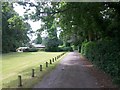
Image Map
Images are licensed for reuse under creativecommons.org/licenses/by-sa/2.0
Notes
- Clicking on the map will re-center to the selected point.
- The higher the marker number, the further away the image location is from the centre of the postcode.
Image Listing (126 Images Found)
Images are licensed for reuse under creativecommons.org/licenses/by-sa/2.0
Image
Details
Distance
1
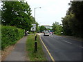
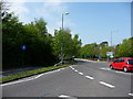
Bournemouth : Wallisdown Road
Approaching University Roundabout.
Image: © Lewis Clarke
Taken: 20 May 2009
0.05 miles
2
Talbot Village: footpath N38 reaches Wallisdown Road
A red car travels westbound along the perpetually busy Wallisdown Road, as we look along the end of a driveway which doubles as a public footpath from the centre of the village.
See Image for the next view behind us along the route.
Image: © Chris Downer
Taken: 9 Jul 2016
0.05 miles
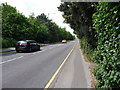
4
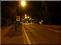
Bournemouth : Wallisdown Road
From the road taken at 9pm heading towards University Roundabout.
Image: © Lewis Clarke
Taken: 8 Mar 2010
0.06 miles
5
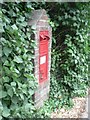
Talbot Village: postbox № BH10 19, Wallisdown Road
This Victorian postbox, mounted in a brick-built pillar, is at the older part of Talbot Village, and has a rather damaged hood.
Image: © Chris Downer
Taken: 6 Jul 2008
0.06 miles
6
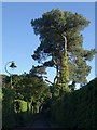
Pines at Talbot Village
A lane leading from the A3049 into the village passes some Scots pines.
Image: © Derek Harper
Taken: 12 Oct 2009
0.07 miles
7

Pines at Talbot Village
Another look at the Scots pines, with ivy-clad trunks, shown in Image
Image: © Derek Harper
Taken: 12 Oct 2009
0.07 miles
8
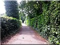
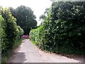
Talbot Village: footpath N38 approaches Wallisdown Road
This public footpath heads south from the centre of Talbot Village, between the high perimeter hedges of two cottages, to reach the main Wallisdown Road.
See Image for a view further along, and Image for the next view of the path behind us, along with a link back to photos on other footpath routes.
Image: © Chris Downer
Taken: 9 Jul 2016
0.07 miles
10
Talbot Village: footpath N38 heads for Wallisdown Road
This public footpath takes the course of one of the estate driveways and leads from path N10 at the centre of the village towards Holdenhurst Road.
(The higher numbered paths hereabouts, such as N38, are not marked on the OS maps as public rights of way, so presumably these are more recent designations.)
See Image for a view over the crossroads behind us, with further links to photos along the paths in all directions, and Image for the next view along the path ahead.
Image: © Chris Downer
Taken: 9 Jul 2016
0.09 miles