IMAGES TAKEN NEAR TO
Wallisdown Road, POOLE, BH12 5BY
Introduction
This page details the photographs taken nearby to Wallisdown Road, BH12 5BY by members of the Geograph project.
The Geograph project started in 2005 with the aim of publishing, organising and preserving representative images for every square kilometre of Great Britain, Ireland and the Isle of Man.

There are currently over 7.5m images from over14,400 individuals and you can help contribute to the project by visiting https://www.geograph.org.uk
Image Map
Images are licensed for reuse under creativecommons.org/licenses/by-sa/2.0
Notes
- Clicking on the map will re-center to the selected point.
- The higher the marker number, the further away the image location is from the centre of the postcode.
Image Listing (55 Images Found)
Images are licensed for reuse under creativecommons.org/licenses/by-sa/2.0
Image
Details
Distance
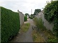
1
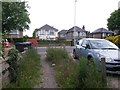
Wallisdown: southern end of footpath U15
This public footpath arrives on the main A3049, Wallisdown Road, from Bascott Close. The frontage line this side of the pavement marks the Bournemouth/Poole borough boundary, meaning that the road and the houses opposite are in Poole, while the houses this side are in Bournemouth.
See Image for the next view on the path behind, with links to further photos along this path and the continuation of it as path U16 to Canford Avenue.
Image: © Chris Downer
Taken: 12 Jul 2016
0.04 miles
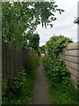
2
Wallisdown: heading for Wallisdown Road on footpath U15
Looking south along this public footpath from Bascott Close, as it nears the main Wallisdown Road.
See Image for the end of the path ahead, and Image for the view behind us.
Image: © Chris Downer
Taken: 12 Jul 2016
0.05 miles
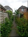
3
Wallisdown: footpath U15 heads north
This short public footpath from Wallisdown Road heads for Bascott Close, and the straight course of the path is continued beyond as another footpath, U16, all the way to Canford Avenue.
See Image for the next view on the path ahead - with links to photos all along paths U15 and U16 ahead, and Image for view behind us.
Image: © Chris Downer
Taken: 12 Jul 2016
0.06 miles
4
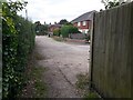
Wallisdown: footpath U15 emerges onto Bascott Close
This short public footpath from Wallisdown Road arrives onto Bascott Close, an offshoot from the dead end of Bascott Road, which is just ahead to the left.
The straight course of the path is continued in the distance as another footpath, U16, all the way to Canford Avenue.
See Image for the view towards us - with links to photos all along path U16 ahead, and Image for the next view on the path behind us.
Image: © Chris Downer
Taken: 12 Jul 2016
0.07 miles
5
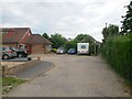
Wallisdown: Bascott Close and footpath U15
Bascott Close is a little offshoot from the dead end of Bascott Road and it contains a few houses around the corner to the left. Meanwhile, a public footpath heads from the right of the caravan, the short distance to Wallisdown Road.
This is essentially a continuation of path U16, which heads behind us along the same straight route.
See Image for the view towards us from the start of the path ahead, and Image for the view here from path U16 behind us. Each has links to further photos along the routes.
Image: © Chris Downer
Taken: 12 Jul 2016
0.07 miles
6
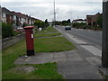
Wallisdown: postbox № BH12 314, Wallisdown Road
This postbox is on the busy A3049 Wallisdown Road; it has its own little paved path across the grass.
Image: © Chris Downer
Taken: 17 Aug 2008
0.07 miles
7
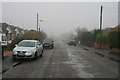
Drizzle in Bascott Road
In the Wallisdown area of Bournemouth.
Image: © David Lally
Taken: 19 Mar 2010
0.08 miles
8
Wallisdown: southern end of footpath U16
This public footpath is long and straight, running from Canford Avenue to Bascott Road. It has several stretches which are access to rear driveways, and even some parts which are the main, front access to houses that have been built in a rather higgledy-piggledy arrangement between the various roads hereabouts.
Here, we see it arrive at the dead end of Bascott Road. A little offshoot extends from the dead end, called Bascott Close, ahead and footpath U15 continues to Wallisdown Road from the right of the caravan.
See Image for the next view on path U16, behind us, and Image for the next view on the path U15 ahead - each with links to further photos along that route.
Image: © Chris Downer
Taken: 12 Jul 2016
0.08 miles
9
Wallisdown: footpath U16 nears Bascott Road
This public footpath is long and straight, running from Canford Avenue to Bascott Road. It has several stretches which are access to rear driveways, and even some parts which are the main, front access to houses that have been built in a rather higgledy-piggledy arrangement between the various roads hereabouts.
Here, we see it approach its southern end, at the dead end of Bascott Road. A little offshoot extends from the dead end, called Bascott Close, in the background and a continuing path goes to Wallisdown Road from the right of the distant caravan.
See Image for the next view on the path ahead, and Image for the next view on the path behind us - each with links to further photos along the route.
Image: © Chris Downer
Taken: 12 Jul 2016
0.09 miles
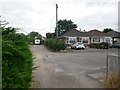
10
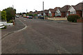
Bascott Road, Wallisdown
Mostly consisting of small detached bungalows. My guess would be late 1940s or early 1950s construction.
Image: © David Lally
Taken: 20 Sep 2009
0.10 miles