IMAGES TAKEN NEAR TO
Vantage Way, POOLE, BH12 4NU
Introduction
This page details the photographs taken nearby to Vantage Way, BH12 4NU by members of the Geograph project.
The Geograph project started in 2005 with the aim of publishing, organising and preserving representative images for every square kilometre of Great Britain, Ireland and the Isle of Man.

There are currently over 7.5m images from over14,400 individuals and you can help contribute to the project by visiting https://www.geograph.org.uk
Image Map
Images are licensed for reuse under creativecommons.org/licenses/by-sa/2.0
Notes
- Clicking on the map will re-center to the selected point.
- The higher the marker number, the further away the image location is from the centre of the postcode.
Image Listing (22 Images Found)
Images are licensed for reuse under creativecommons.org/licenses/by-sa/2.0
Image
Details
Distance
2
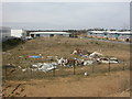
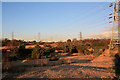
Manning's Heath, flytipping
Flytipping on development site at Fulcrum Business Park. Why didn't the owners secure the site properly?
Image: © Mike Faherty
Taken: 7 Mar 2009
0.05 miles
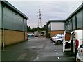
3
Bournemouth & Poole College, construction academy
Full name, the Bournemouth & Poole College, Academy of Construction Technologies; on the Fulcrum Business Park. I trust students learn more about building than is on display externally here at one of several identikit structures. http://www.thecollege.co.uk/faculties/technology/index.php
Image: © Mike Faherty
Taken: 7 Mar 2009
0.06 miles
4
Pond and pylons on Canford Heath
The part of the heath south of the A3049 dual carriageway which, although not seen, this picture is looking across.
Image: © Peter Facey
Taken: 25 Jan 2007
0.12 miles
5
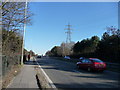
Poole : Canford Way A3049
Canford Way which is on the way to Bournemouth and Ringwood Road.
Image: © Lewis Clarke
Taken: 8 Mar 2010
0.12 miles
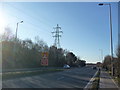
6
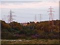
Canford Heath: dual-carriageway wires and lights
Two rows of lampposts – lining the side of the dual-carriageway A3049, unseen in the dip – are themselves flanked by two electricity transmission lines on the southern edge of Canford Heath.
Image: © Chris Downer
Taken: 9 Jul 2009
0.13 miles
7
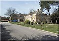
Alderney Hospital
Built in the 19th Century, this hospital now specialises in the care of those with Mental Health problems or Learning Disabilities.
Image: © mike smith
Taken: 6 Apr 2007
0.14 miles
8
Poole : Canford Way A3049
Canford Way looking towards the Canford Heath.
Image: © Lewis Clarke
Taken: 8 Mar 2010
0.15 miles
9
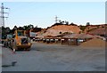
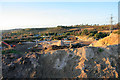
Suttles Sand and Gravel Yard, Canford Heath
This yard sell all kinds of sand and gravel. The different kinds are separated into bunkers (which can be seen in the centre of the image) ready for loading onto customers vehicles. They include such products as 20mm gravel, washed plastering sand, builders sand, all in ballast and many others. From the terrain in the background where sandy strata are visible, it appears as if a lot of these products are dug up locally.
Image: © Nigel Mykura
Taken: 27 Apr 2011
0.15 miles