IMAGES TAKEN NEAR TO
Aspen Gardens, POOLE, BH12 4DF
Introduction
This page details the photographs taken nearby to Aspen Gardens, BH12 4DF by members of the Geograph project.
The Geograph project started in 2005 with the aim of publishing, organising and preserving representative images for every square kilometre of Great Britain, Ireland and the Isle of Man.

There are currently over 7.5m images from over14,400 individuals and you can help contribute to the project by visiting https://www.geograph.org.uk
Image Map
Images are licensed for reuse under creativecommons.org/licenses/by-sa/2.0
Notes
- Clicking on the map will re-center to the selected point.
- The higher the marker number, the further away the image location is from the centre of the postcode.
Image Listing (23 Images Found)
Images are licensed for reuse under creativecommons.org/licenses/by-sa/2.0
Image
Details
Distance
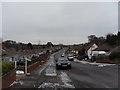
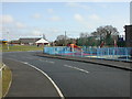
1
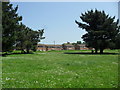
Slepe Crescent
Looking across open ground in Rossmore.
Image: © Burgess Von Thunen
Taken: 22 May 2012
0.05 miles
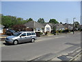
2
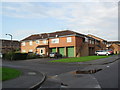
Aspen Gardens
1980s properties in Rossmore.
Image: © Burgess Von Thunen
Taken: 10 Nov 2011
0.06 miles
3
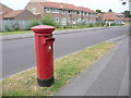
Branksome: postbox № BH12 103, Aspen Gardens
This postbox is currently missing its information plate; indeed missing the border that would keep it in place. The little sticker is one of those that were affixed in autumn 2007 explaining that Sunday collections would cease from 27 October that year (these were put on every box since the majority that did not have Sunday collections had details of the nearest that did) – so presumably the plate has been missing at least since then.
Image: © Chris Downer
Taken: 28 Jun 2009
0.11 miles
4
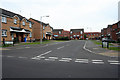
SZ057933: Cashmoor Close
Looking into the housing estate on Cashmoor Close. Picture taken from Aspen Road.
Image: © Kris
Taken: 6 May 2006
0.14 miles
5
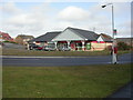
Rossmore, shopping parade
Small parade at the junction of Arne and Melbury Avenues; currently comprising convenience store, take-away, vacant and fish & chip shop.
Image: © Mike Faherty
Taken: 24 Feb 2010
0.15 miles
7
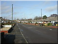
Rossmore, Bloxworth Road
Roads in the North of this square comprise almost all bungalows. Roads are named after Dorset towns and villages; this road is bounded to the North by Image
Image: © Mike Faherty
Taken: 24 Feb 2010
0.15 miles
8
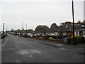
Bloxworth Road
1960s bungalows in Rossmore.
Image: © Burgess Von Thunen
Taken: 10 Nov 2011
0.16 miles
9
Bloxworth Road
1960s bungalows in Rossmore. The car looks like a Vauxhall Astra LS MkIV Estate but with 1987 number plates. The MkIV came out in 1998.
Image: © Burgess Von Thunen
Taken: 22 May 2012
0.18 miles
10
Rossmore, play facility
Arne Avenue Play Facility. On the link photo, it is shown as "play area"; I wonder why the council had to rename it in such an unfriendly manner? http://www.leisureprojects.net/Playbuilder/arneavenue.htm
Image: © Mike Faherty
Taken: 24 Feb 2010
0.20 miles