IMAGES TAKEN NEAR TO
Trinidad Crescent, POOLE, BH12 3NN
Introduction
This page details the photographs taken nearby to Trinidad Crescent, BH12 3NN by members of the Geograph project.
The Geograph project started in 2005 with the aim of publishing, organising and preserving representative images for every square kilometre of Great Britain, Ireland and the Isle of Man.

There are currently over 7.5m images from over14,400 individuals and you can help contribute to the project by visiting https://www.geograph.org.uk
Image Map
Images are licensed for reuse under creativecommons.org/licenses/by-sa/2.0
Notes
- Clicking on the map will re-center to the selected point.
- The higher the marker number, the further away the image location is from the centre of the postcode.
Image Listing (10 Images Found)
Images are licensed for reuse under creativecommons.org/licenses/by-sa/2.0
Image
Details
Distance
1
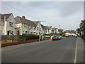
Trinidad Crescent
Post-WW2 council houses in the Trinidad Estate, so called because the area was previously a depot for the Limmer & Trinidad Lake Asphalt Co.
Image: © Mike Faherty
Taken: 7 Mar 2009
0.06 miles
2
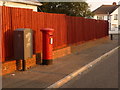
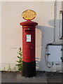
Rossmore: postbox № BH12 218, Worrell Drive
This postbox is a George VI-reign one; it is emptied finally at 5:30pm on weekdays and at 12:15pm on Saturdays.
Image: © Chris Downer
Taken: 29 Jun 2009
0.06 miles
3
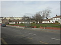
Trinidad House
Sheltered housing development on Rossmore Road; the area is named after the Limmer & Trinidad Lake Asphalt Co., which used to have a depot here. http://www.housingcare.org/sheltered-housing/scheme-2611-trinidad-house-poole-england.aspx
Image: © Mike Faherty
Taken: 7 Mar 2009
0.10 miles
4
Trinidad Boys' Club
Boxing & boys' club in the middle of the Trinidad Estate, so called because the area used to be a depot for Limmer & Trinidad Lake Asphalt Co.
Image: © Mike Faherty
Taken: 7 Mar 2009
0.12 miles
5
Alderney: postbox № BH12 163, Herbert Avenue
This postbox stands outside Alderney Post Office, on the corner of Ringwood Road. These post office direction signs are becoming increasingly rare, not just because post offices are fewer but also through vandalism and, presumably, accidental damage.
Image: © Chris Downer
Taken: 29 Jun 2009
0.14 miles
6
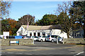
Alderney Manor Community and Social Club
On the corner of Herbert and Berkeley Avenues.
Image: © Robin Webster
Taken: 25 Nov 2016
0.15 miles
7
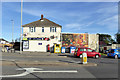
McColl's Local
A post office, off licence and general convenience store.
Image: © Robin Webster
Taken: 25 Nov 2016
0.16 miles
8
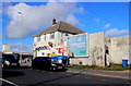
Advertising Hoarding
This hoarding with a decaying advert proclaiming Specsavers can provide complete glasses for £25 is on the side of a convenience store and post office on the corner of Herbert Avenue and the Ringwood Rd the B3068
Image: © Nigel Mykura
Taken: 7 Feb 2019
0.16 miles
9
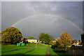
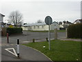
Turf Zone "RossmoreRoad"
Green off Rossmore Road.
Image: © Ian S
Taken: 15 Nov 2022
0.16 miles
10
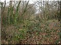
Alderney, Bourne Valley Park
Previously Alderney Recreation Ground, the stream (mainly hidden under brambles above) used to be culverted; in 2006, the stream was exposed, and the open space was made more diverse and attractive. The stream feeds into the Bourne, a kilometre away to the North-East. Seen here, woodland walk, at Herbert Avenue.http://www.bournestreampartnership.org.uk/alderney_recreation_ground.htm
Image: © Mike Faherty
Taken: 7 Mar 2009
0.24 miles