IMAGES TAKEN NEAR TO
Cranbrook Road, POOLE, BH12 3BT
Introduction
This page details the photographs taken nearby to Cranbrook Road, BH12 3BT by members of the Geograph project.
The Geograph project started in 2005 with the aim of publishing, organising and preserving representative images for every square kilometre of Great Britain, Ireland and the Isle of Man.

There are currently over 7.5m images from over14,400 individuals and you can help contribute to the project by visiting https://www.geograph.org.uk
Image Map
Images are licensed for reuse under creativecommons.org/licenses/by-sa/2.0
Notes
- Clicking on the map will re-center to the selected point.
- The higher the marker number, the further away the image location is from the centre of the postcode.
Image Listing (11 Images Found)
Images are licensed for reuse under creativecommons.org/licenses/by-sa/2.0
Image
Details
Distance
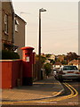
1
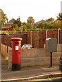
Parkstone: postbox № BH12 150, Croft Road
This Victorian postbox is emptied finally at 5:30pm on weekdays and at noon on Saturdays. Alongside is a drop box (see below).
Image: © Chris Downer
Taken: 9 Aug 2009
0.07 miles
2
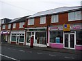
Newtown: the post office
Looking across Sea View Road at the parade of shops including the post office, which moved across here from premises opposite the northern end of this road, a short distance away, about 20 years ago (possibly more).
There has been a post office in Newtown since 1 May 1882.
Image: © Chris Downer
Taken: 10 Aug 2009
0.18 miles
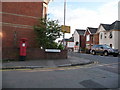
3
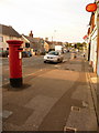
Newtown: postbox № BH12 45, Sea View Road
This Elizabeth II-reign postbox faces Image and is emptied finally at 5:30pm on weekdays and at noon on Saturdays.
Image: © Chris Downer
Taken: 9 Aug 2009
0.18 miles
4
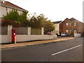
Parkstone: postbox № BH12 142, Crest Road
An Elizabeth II-reign postbox, emptied finally at 5:30pm on weekdays and at noon on Saturdays. Beyond is Uppleby Road.
Image: © Chris Downer
Taken: 5 Aug 2009
0.19 miles
5
Parkstone: postbox № BH12 48, Farcroft Road
This George V-reign postbox faces the main Ashley Road; if it was round the corner it would be in BH14. It is emptied finally at 5:30pm on weekdays and at noon on Saturdays.
Image: © Chris Downer
Taken: 9 Aug 2009
0.21 miles
6
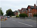
Ashley Rd, parkstone
This view is west along Ashley Rd towards its junction with Sea View Rd. Taken from close to North Rd
Image: © Nigel Mykura
Taken: 12 May 2009
0.21 miles
7
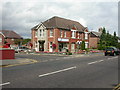
Parkstone, funeral directors
Anthony Ives, on Ashley Road. http://www.anthonyives.co.uk/
Image: © Mike Faherty
Taken: 7 Jul 2009
0.21 miles
8
Parkstone, children's centre
On Ashley Road; the sign at the front calls it a Children's Centre, but Poole BC calls it a Family Centre. Offers clinics, groups, toy library, and other facilities. http://www.poole.gov.uk/children/services/ref:S464C2048C9F40/aka:Ted+Webster+Family+Centre/
Image: © Mike Faherty
Taken: 7 Jul 2009
0.21 miles
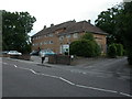
9
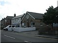
Parkstone, citadel
Salvation Army Citadel in Sea View Road; an inscription around the circular gable window reads "SALVATION ARMY BLOOD AND FIRE". Services on offer on Sundays at 10.30 am.
Image: © Mike Faherty
Taken: 7 Jul 2009
0.23 miles
10
Parkstone: postbox № BH12 11, Hillcrest Road
An Edward VII-reign postbox by the corner of Sea View Road, this box is emptied finally at 5:30pm on weekdays and at noon on Saturdays.
Image: © Chris Downer
Taken: 5 Aug 2009
0.24 miles