IMAGES TAKEN NEAR TO
Southill Road, POOLE, BH12 3AR
Introduction
This page details the photographs taken nearby to Southill Road, BH12 3AR by members of the Geograph project.
The Geograph project started in 2005 with the aim of publishing, organising and preserving representative images for every square kilometre of Great Britain, Ireland and the Isle of Man.

There are currently over 7.5m images from over14,400 individuals and you can help contribute to the project by visiting https://www.geograph.org.uk
Image Map
Images are licensed for reuse under creativecommons.org/licenses/by-sa/2.0
Notes
- Clicking on the map will re-center to the selected point.
- The higher the marker number, the further away the image location is from the centre of the postcode.
Image Listing (9 Images Found)
Images are licensed for reuse under creativecommons.org/licenses/by-sa/2.0
Image
Details
Distance
1
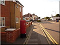
Parkstone: postbox № BH12 158, Upper Road
This little postbox, by the corner of Southill Road, is emptied finally at 5:30pm on weekdays and at 12:15pm on Saturdays.
Image: © Chris Downer
Taken: 5 Aug 2009
0.06 miles
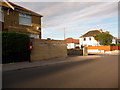
2

Parkstone: view across suburbia
Looking roughly east from Image in this area of densely packed housing.
Image: © Chris Downer
Taken: 5 Aug 2009
0.11 miles
3
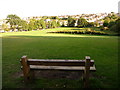
Parkstone: a bench with a view
A large patch of open space among the dense housing area of Parkstone, north of Ashley Road. The roads here tend to be in a fairly neat criss-cross formation, although parts of it are on quite steep gradients. Here we get an idea of the layout.
Image: © Chris Downer
Taken: 5 Aug 2009
0.15 miles
4

Parkstone: postbox № BH12 44, Livingstone Road
This postbox stands on the corner of Churchill Road and, according to the large-scale mapping, must have been repositioned at some stage from the next junction south. It receives its final collection on weekdays at 5:30pm and on Saturdays at 12:30pm.
Image: © Chris Downer
Taken: 5 Aug 2009
0.17 miles
5
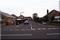
Junction of Almond Grove and Rossmore Road, Poole
This picture taken standing on Rossmore Road looking out towards Almond Grove.
Image: © Kris
Taken: 6 May 2006
0.22 miles
6
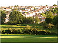
Parkstone: houses in Victoria Road
Looking out from Image, along the roofs of Victoria Road, one of many long straight roads running roughly north-south, to the north of Ashley Road – at about 8 o'clock on a sunny evening.
This rather nice drop of weather was unimaginable a few hours ago, after a day of constant drizzle.
Image: © Chris Downer
Taken: 5 Aug 2009
0.23 miles
7
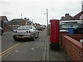
Parkstone: postbox № BH12 53, Rossmore Road
This postbox replaced one a little to the east of here, outside Rossmore Post Office, when the post office closed in 2004. It is emptied finally at 5:30pm on weekdays and at 12:15pm on Saturdays.
Image: © Chris Downer
Taken: 5 Aug 2009
0.24 miles
8
Rossmore, postbox BH12 53
Postbox on Rossmore Road; type K, introduced in 1978. To the left can be seen the corner of Image
Image: © Mike Faherty
Taken: 7 Mar 2009
0.24 miles
9
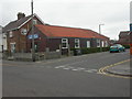
Rossmore Gospel Church
Wooden church building at the junction of Rossmore & Pembroke Roads.
Image: © Mike Faherty
Taken: 7 Mar 2009
0.24 miles