IMAGES TAKEN NEAR TO
Heatherlands Rise, POOLE, BH12 2LN
Introduction
This page details the photographs taken nearby to Heatherlands Rise, BH12 2LN by members of the Geograph project.
The Geograph project started in 2005 with the aim of publishing, organising and preserving representative images for every square kilometre of Great Britain, Ireland and the Isle of Man.

There are currently over 7.5m images from over14,400 individuals and you can help contribute to the project by visiting https://www.geograph.org.uk
Image Map
Images are licensed for reuse under creativecommons.org/licenses/by-sa/2.0
Notes
- Clicking on the map will re-center to the selected point.
- The higher the marker number, the further away the image location is from the centre of the postcode.
Image Listing (10 Images Found)
Images are licensed for reuse under creativecommons.org/licenses/by-sa/2.0
Image
Details
Distance
1
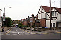
Junction of Churchill Road and New Road
This picture was taken standing on Churchill Road, looking out towards New Road.
Image: © Kris
Taken: 6 May 2006
0.12 miles

3
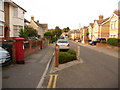
Parkstone: postbox № BH12 10, Albert Road
This Elizabeth II-reign postbox is situated in Albert Road, in the vast, densely packed criss-cross pattern of residential roads which are mainly Victorian and early 20th-century. Thus, few houses have off-road accommodation for cars. The box is emptied finally at 5:30pm on weekdays and at 12:15pm on Saturdays.
Image: © Chris Downer
Taken: 9 Aug 2009
0.18 miles
4

Parkstone: postbox № BH12 44, Livingstone Road
This postbox stands on the corner of Churchill Road and, according to the large-scale mapping, must have been repositioned at some stage from the next junction south. It receives its final collection on weekdays at 5:30pm and on Saturdays at 12:30pm.
Image: © Chris Downer
Taken: 5 Aug 2009
0.19 miles
5
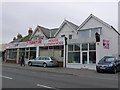
Furniture Clearance
This second hand furniture shop is on the north side of Ashley Rd close to the junction with Albert Rd.
Image: © Nigel Mykura
Taken: 12 May 2009
0.24 miles
6
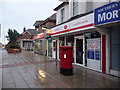
Parkstone: Ashley Road West Post Office and postbox № BH14 12
Now that the Ashley Road East Post Office has closed (2004), the name Ashley Road West for this branch seems a little odd, since it's the only office in Ashley Road. The postbox is emptied finally at 5:30pm on weekdays and at noon on Saturdays.
There had previously been a single office in Ahsley Road – probably this one – called plain 'Ashley Road' from 1 September 1893 until 1911 when the second one opened.
Image: © Chris Downer
Taken: 3 Aug 2009
0.24 miles
7
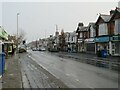
Ashley Road, Upper Parkstone, Poole
Ashley Road is on the route of the B3061 as it passes through Upper Parkstone.
This image was taken on a very cold December day. There had been a dusting of snow overnight, most of which had melted but there were still some slushy remnants in the bus stop lay-by in the foreground.
Image: © Malc McDonald
Taken: 11 Dec 2022
0.24 miles
8
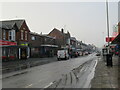
Ashley Road, Upper Parkstone, Poole
Ashley Road is on the route of the B3061 as it passes through Upper Parkstone.
This image was taken on a very cold December day. There had been a dusting of snow overnight, most of which had melted but there were still some slushy remnants in the bus stop lay-by in the foreground. In the distance, a transmission mast is just visible although the top of it is shrouded by mist.
Image: © Malc McDonald
Taken: 11 Dec 2022
0.24 miles
9
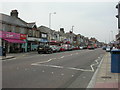
Parkstone, shops
Ashley Road is Upper Parkstone's shopping centre; shops shown here include florist, sandwich bar, health foods, estate agent, barber, newsagent, shoe repairs & keys.
Image: © Mike Faherty
Taken: 6 Jun 2009
0.25 miles
10
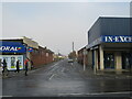
Jubilee Road, Upper Parkstone, Poole
Jubilee Road is a residential road in Upper Parkstone, a suburb of Poole.
This image was taken on a very cold December day. There had been a light dusting of snow overnight. This was now melting and turning into slush.
Image: © Malc McDonald
Taken: 11 Dec 2022
0.25 miles