IMAGES TAKEN NEAR TO
Sunnyside Road, POOLE, BH12 2LG
Introduction
This page details the photographs taken nearby to Sunnyside Road, BH12 2LG by members of the Geograph project.
The Geograph project started in 2005 with the aim of publishing, organising and preserving representative images for every square kilometre of Great Britain, Ireland and the Isle of Man.

There are currently over 7.5m images from over14,400 individuals and you can help contribute to the project by visiting https://www.geograph.org.uk
Image Map
Images are licensed for reuse under creativecommons.org/licenses/by-sa/2.0
Notes
- Clicking on the map will re-center to the selected point.
- The higher the marker number, the further away the image location is from the centre of the postcode.
Image Listing (6 Images Found)
Images are licensed for reuse under creativecommons.org/licenses/by-sa/2.0
Image
Details
Distance
1
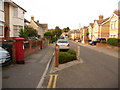
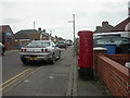
Parkstone: postbox № BH12 10, Albert Road
This Elizabeth II-reign postbox is situated in Albert Road, in the vast, densely packed criss-cross pattern of residential roads which are mainly Victorian and early 20th-century. Thus, few houses have off-road accommodation for cars. The box is emptied finally at 5:30pm on weekdays and at 12:15pm on Saturdays.
Image: © Chris Downer
Taken: 9 Aug 2009
0.09 miles

3
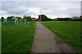
Turf Zone "AlbertHerbert"
At Hatchards Field.
Image: © Ian S
Taken: 15 Nov 2022
0.18 miles
4
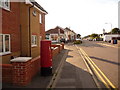
Parkstone: postbox № BH12 53, Rossmore Road
This postbox replaced one a little to the east of here, outside Rossmore Post Office, when the post office closed in 2004. It is emptied finally at 5:30pm on weekdays and at 12:15pm on Saturdays.
Image: © Chris Downer
Taken: 5 Aug 2009
0.22 miles
5
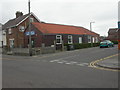
Rossmore Gospel Church
Wooden church building at the junction of Rossmore & Pembroke Roads.
Image: © Mike Faherty
Taken: 7 Mar 2009
0.22 miles
6
Rossmore, postbox BH12 53
Postbox on Rossmore Road; type K, introduced in 1978. To the left can be seen the corner of Image
Image: © Mike Faherty
Taken: 7 Mar 2009
0.24 miles