IMAGES TAKEN NEAR TO
Rossmore Road, POOLE, BH12 2HG
Introduction
This page details the photographs taken nearby to Rossmore Road, BH12 2HG by members of the Geograph project.
The Geograph project started in 2005 with the aim of publishing, organising and preserving representative images for every square kilometre of Great Britain, Ireland and the Isle of Man.

There are currently over 7.5m images from over14,400 individuals and you can help contribute to the project by visiting https://www.geograph.org.uk
Image Map
Images are licensed for reuse under creativecommons.org/licenses/by-sa/2.0
Notes
- Clicking on the map will re-center to the selected point.
- The higher the marker number, the further away the image location is from the centre of the postcode.
Image Listing (12 Images Found)
Images are licensed for reuse under creativecommons.org/licenses/by-sa/2.0
Image
Details
Distance
1
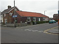
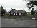
Rossmore Gospel Church
Wooden church building at the junction of Rossmore & Pembroke Roads.
Image: © Mike Faherty
Taken: 7 Mar 2009
0.03 miles
2
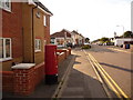
Parkstone: postbox № BH12 53, Rossmore Road
This postbox replaced one a little to the east of here, outside Rossmore Post Office, when the post office closed in 2004. It is emptied finally at 5:30pm on weekdays and at 12:15pm on Saturdays.
Image: © Chris Downer
Taken: 5 Aug 2009
0.03 miles
3
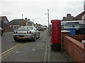
Rossmore, postbox BH12 53
Postbox on Rossmore Road; type K, introduced in 1978. To the left can be seen the corner of Image
Image: © Mike Faherty
Taken: 7 Mar 2009
0.04 miles
4
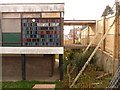
Rossmore: detail of the old library building
This is our last chance to see the former library building in Herbert Avenue, as demolition is underway (see Image). It has lain idle for the last four years since the library moved into new premises nearby. Such is the gradient here that the entrance to the building was virtually on the ground floor level at this western end, while at the eastern end this was definitely the first floor (see above link).
As well as looking at the tilework depicting bookshelves, we see the dead-end of Pembroke Road in the distance – a pathway leads from there to Herbert Avenue to the right of the cordon, off which the library entrance was accessed.
Image: © Chris Downer
Taken: 30 Oct 2009
0.10 miles
5
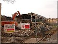
Rossmore: demolition of the old library building
This 60s building on Herbert Avenue was rendered redundant in 2005 when the Rossmore branch of the Borough of Poole Library Service moved into brand new purpose-built premises on the campus of the nearby secondary school. The second word of the name of the contractors carrying out the demolition – Hughes & Salvidge – seems rather ironic.
Image: © Chris Downer
Taken: 30 Oct 2009
0.11 miles
6
Rossmore, old library
1960s-looking building, replaced in 2005 by Image The old library does not seem to have found a new role.
Image: © Mike Faherty
Taken: 7 Mar 2009
0.12 miles
7
Rossmore, Church of the Good Shepherd
On Herbert Avenue; founded 1931, from when this wooden building presumably dates. For more information, see http://www.cogspoole.co.uk/
Image: © Mike Faherty
Taken: 7 Mar 2009
0.15 miles
8
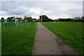
Turf Zone "AlbertHerbert"
At Hatchards Field.
Image: © Ian S
Taken: 15 Nov 2022
0.17 miles
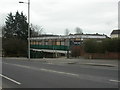
9
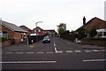
Junction of Almond Grove and Rossmore Road, Poole
This picture taken standing on Rossmore Road looking out towards Almond Grove.
Image: © Kris
Taken: 6 May 2006
0.18 miles
10
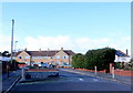
Traffic Calming Measures in Melbury Avenue
This barrier consisting of a brick wall, some pillars and a "sleeping policeman" are at the end of Melbury Avenue close to its junction with Turbary Rd. The wall has recently been rebuilt indicating it has been doing its job to impede the passage of motor vehicles.
Image: © Nigel Mykura
Taken: 7 Feb 2019
0.21 miles