IMAGES TAKEN NEAR TO
Gorleston Road, POOLE, BH12 1NW
Introduction
This page details the photographs taken nearby to Gorleston Road, BH12 1NW by members of the Geograph project.
The Geograph project started in 2005 with the aim of publishing, organising and preserving representative images for every square kilometre of Great Britain, Ireland and the Isle of Man.

There are currently over 7.5m images from over14,400 individuals and you can help contribute to the project by visiting https://www.geograph.org.uk
Image Map
Images are licensed for reuse under creativecommons.org/licenses/by-sa/2.0
Notes
- Clicking on the map will re-center to the selected point.
- The higher the marker number, the further away the image location is from the centre of the postcode.
Image Listing (72 Images Found)
Images are licensed for reuse under creativecommons.org/licenses/by-sa/2.0
Image
Details
Distance
1
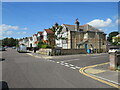
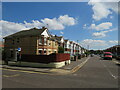
Gorleston Road, Branksome, Poole
Gorleston Road is a residential road in Branksome, a suburb of Poole.
Image: © Malc McDonald
Taken: 25 Aug 2021
0.02 miles
3
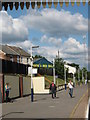
Branksome Station
Plain Victorian station, opened 1893, facing Poole, to the West. Note wooden awning & cast iron pillar decoration. Taken on a cold, wet autumn afternoon.
http://www.sdjr.net/locations/branksome.html
Image: © Mike Faherty
Taken: 1 Nov 2008
0.06 miles
4

Branksome Station
View SW, towards Poole and Weymouth; ex-London & South Western, London etc. - Southampton - Bournemouth - Poole - Weymouth main line.
Image: © Ben Brooksbank
Taken: 20 Apr 1963
0.07 miles
5

12:34:56 on 07.08.09
Looking east along the westbound platform of Branksome railway station – at the moment of the numerologically quirky date/time combination of...
12:34:56 on 07.08.09
The camera shutter opened and closed at a faster rate than the flickering of the dots that make up the display, resulting in this only semi-legible image. I have therefore manually superimposed the missing dots in this image: Image to convey how the scene looked to the naked eye.
Image: © Chris Downer
Taken: 7 Aug 2009
0.07 miles
6

Significant figures
Looking east along the westbound platform of Branksome railway station – at the moment of the numerologically quirky date/time combination of...
12:34:56 on 07.08.09
The camera shutter actually opened and closed at a faster rate than the flickering of the dots that make up the display. This is thus one picture taken at the all-important moment, with some lines of dots manually inserted from another picture taken a minute or so earlier. I hope nobody minds my cheating in this way! The original image can be seen here: Image
Image: © Chris Downer
Taken: 7 Aug 2009
0.07 miles
7
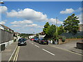
Sheringham Road, Branksome, Poole
Sheringham Road is a residential road in Branksome, a suburb of Poole.
Image: © Malc McDonald
Taken: 25 Aug 2021
0.07 miles
8
Gorleston Road, Branksome, Poole
Gorleston Road is a residential road in Branksome, a suburb of Poole.
Image: © Malc McDonald
Taken: 25 Aug 2021
0.07 miles
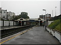
9
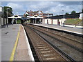
Branksome railway station, Dorset
Opened in 1893 on the London & South Western Railway's main line from Southampton to Weymouth. View west towards Parkstone and Weymouth.
Image: © Nigel Thompson
Taken: 9 Jul 2011
0.09 miles
10
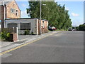
Branksome, old level crossing gate
Gate (blue post, rusting gate) in Cromer Road, on the site of the old railway line from clay pits at Alder Hills to The Bourne Valley Pottery, now occupied by Image, and then on through here to sidings in Branksome Station.
Image: © Mike Faherty
Taken: 28 May 2009
0.09 miles