IMAGES TAKEN NEAR TO
Yarmouth Road, POOLE, BH12 1JN
Introduction
This page details the photographs taken nearby to Yarmouth Road, BH12 1JN by members of the Geograph project.
The Geograph project started in 2005 with the aim of publishing, organising and preserving representative images for every square kilometre of Great Britain, Ireland and the Isle of Man.

There are currently over 7.5m images from over14,400 individuals and you can help contribute to the project by visiting https://www.geograph.org.uk
Image Map
Images are licensed for reuse under creativecommons.org/licenses/by-sa/2.0
Notes
- Clicking on the map will re-center to the selected point.
- The higher the marker number, the further away the image location is from the centre of the postcode.
Image Listing (32 Images Found)
Images are licensed for reuse under creativecommons.org/licenses/by-sa/2.0
Image
Details
Distance
1
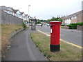
Branksome: postbox № BH12 243, Yarmouth Road
This large postbox has been repositioned (or, more likely, been provided as a replacement for the old box) in the last couple of years. Wroxham Road is the turning just behind us, and on its next junction up there were a couple of shops on a corner which had become vacant – the postbox was outside those shops. The shops have recently been demolished and housing built in their place; they did include a post office for a short time – from 1932 until the Second World War.
This box is currently missing its collection-times plate – or perhaps it is still awaiting one – although there are the words 'IN USE' scrawled on the white panel.
Image: © Chris Downer
Taken: 28 Jun 2009
0.07 miles
2
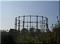
Empty Gas Holder adjacent to Guest Avenue
Taken from footpath leading to Alder Road
Image: © Steve Sheppard
Taken: 9 Apr 2007
0.11 miles
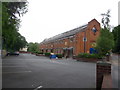
3
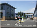
Branksome Business Park
Newly-built, on Bourne Valley Road; http://www.bsbcharteredarchitects.co.uk/branksome-business-park.htm
Image: © Mike Faherty
Taken: 23 Jun 2009
0.14 miles
5
Branksome, Poole electrity depot
Sub-station on Bourne Valley Road, just South of its junction with Coy Pond Road.
Image: © Mike Faherty
Taken: 23 Jun 2009
0.16 miles
6
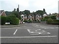
Shortest named, motorable, through road?
I nominate this one as a candidate. Thetford Road is so short that it only requires six white lines down its entire length. It is named, like its neighbours, after Norfolk towns, although no properties have a Thetford Road postal address (the two near corner houses are in Yarmouth Road and the farther two in Sheringham Road).
It is not a segment of a road which continues beyond some barrier – this is all there is of it.
A strong counterclaim to this title will be found at: Image, and another at: Image
Image: © Chris Downer
Taken: 15 Jul 2007
0.18 miles
7
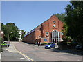
Branksome, Old Generator House
On Bourne Valley Road, opposite Image; now mainly converted to offices.
Image: © Mike Faherty
Taken: 23 Jun 2009
0.18 miles
8
Branksome: the Old Generator House
A rather nice old building, part of the industrial area of Bourne Valley – a building which did indeed used to be one of the Southern Electricity Board's several premises along here.
Image: © Chris Downer
Taken: 28 Jun 2009
0.20 miles
9
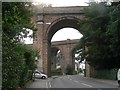
Branksome: double viaduct
Surrey Road passes under two viaducts in quick succession, though only one now carries track. The near viaduct used to provide rail access to the old Bournemouth West station, which is now a train maintenance depot. The depot is accessed only via the southern 'arm' of the triangle (see map), meaning that this particular viaduct is redundant. The far viaduct carries the mainline between Weymouth and London Waterloo.
Image: © Chris Downer
Taken: 15 Jul 2007
0.20 miles
10
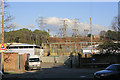
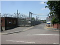
Electricity substation, Poole
Seen from Yarmouth Road. 132 KV/33 KV.
Image: © Peter Facey
Taken: 25 Jan 2007
0.20 miles