IMAGES TAKEN NEAR TO
Guest Close, POOLE, BH12 1JF
Introduction
This page details the photographs taken nearby to Guest Close, BH12 1JF by members of the Geograph project.
The Geograph project started in 2005 with the aim of publishing, organising and preserving representative images for every square kilometre of Great Britain, Ireland and the Isle of Man.

There are currently over 7.5m images from over14,400 individuals and you can help contribute to the project by visiting https://www.geograph.org.uk
Image Map
Images are licensed for reuse under creativecommons.org/licenses/by-sa/2.0
Notes
- Clicking on the map will re-center to the selected point.
- The higher the marker number, the further away the image location is from the centre of the postcode.
Image Listing (15 Images Found)
Images are licensed for reuse under creativecommons.org/licenses/by-sa/2.0
Image
Details
Distance
1
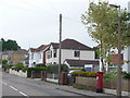
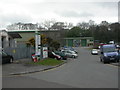
Branksome: postbox № BH12 236, Winston Avenue
An Elizabeth II-reign box, right in the dip of Winston Avenue, emptied finally at 5:30pm on weekdays and at 12:15pm on Saturdays.
Image: © Chris Downer
Taken: 28 Jun 2009
0.05 miles
2
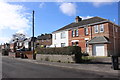
Houses on Guest Avenue
These semi detached red brick houses , some of which have been considerabley extended are in the residential district of Branksome known as Bourne Valley.
Image: © Nigel Mykura
Taken: 7 Feb 2019
0.05 miles
3
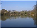
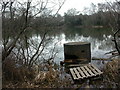
Pond on Alder Hills Nature Reserve
Pond formed from clay workings, with the clay used for builders requirements - bricks, clay pipes, etc. Clay extraction stopped in 1948. At one time under threat of development (a huge Sainsbury's has been built on part of the original site) this remnant of old Dorset heathland with its pond remains surrounded by housing, light industrial and, of course, Sainsbury's. It is now a Nature Reserve.
Image: © Steve Sheppard
Taken: 9 Apr 2007
0.16 miles
4
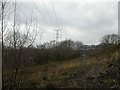
Alder Hills, electricity pylons
Pylons striding across Alder Hills Nature Reserve http://www.boroughofpoole.com/facilities/ref:F465e9bc765cc1/. In the distance to the right are buildings at Image
Image: © Mike Faherty
Taken: 10 Mar 2009
0.19 miles
5
Alder Hills Nature Reserve, lake
Lake formed by old clay pit, previously owned by Sharp Jones' Bourne Valley Pottery, one of several clay pits in the area; abandoned 1948. The circular concrete structure in the foreground is probably part of the old workings.http://www.bournestreampartnership.org.uk/alder_hills_LNR.htm
Image: © Mike Faherty
Taken: 10 Mar 2009
0.20 miles
6
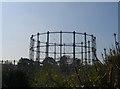
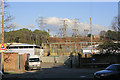
Empty Gas Holder adjacent to Guest Avenue
Taken from footpath leading to Alder Road
Image: © Steve Sheppard
Taken: 9 Apr 2007
0.20 miles
7
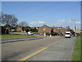
Branksome: Farnham Road
Farnham Road is part of this large-ish estate built in the early 1980s; this section runs directly the electricity cables.
Image: © Chris Downer
Taken: 28 Jun 2009
0.22 miles
8
Winston Avenue
At the junction with Farnham Road.
Image: © Burgess Von Thunen
Taken: 21 Mar 2012
0.22 miles
9
Branksome Business Centre
In Sharp Road & Cortry Close; one of 3 local industrial/business centres.
Image: © Mike Faherty
Taken: 10 Mar 2009
0.23 miles
10
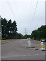
Electricity substation, Poole
Seen from Yarmouth Road. 132 KV/33 KV.
Image: © Peter Facey
Taken: 25 Jan 2007
0.23 miles