IMAGES TAKEN NEAR TO
Bourne Valley Road, POOLE, BH12 1DU
Introduction
This page details the photographs taken nearby to Bourne Valley Road, BH12 1DU by members of the Geograph project.
The Geograph project started in 2005 with the aim of publishing, organising and preserving representative images for every square kilometre of Great Britain, Ireland and the Isle of Man.

There are currently over 7.5m images from over14,400 individuals and you can help contribute to the project by visiting https://www.geograph.org.uk
Image Map
Images are licensed for reuse under creativecommons.org/licenses/by-sa/2.0
Notes
- Clicking on the map will re-center to the selected point.
- The higher the marker number, the further away the image location is from the centre of the postcode.
Image Listing (48 Images Found)
Images are licensed for reuse under creativecommons.org/licenses/by-sa/2.0
Image
Details
Distance
1
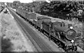
Down parcels train approaching Branksome station
View eastwards towards Bournemouth Central: ex-LSW London - Southampton etc. - Weymouth/Bournemouth West main line. The locomotive is ex-LSW Drummond T9 4-4-0 No. 30285 (built 1/1900, withdrawn 6/58). The headcode is for a Bournemouth Central - Dorchester goods train.
Image: © Ben Brooksbank
Taken: 16 Jun 1951
0.04 miles
2
WWII defences in the environs of Bournemouth & Christchurch: Bourne Valley viaducts - pillbox
-
Pillbox (type FW3/22): DoB ID: e11751
One's imagination is required here, but trust me, there really is a pillbox under that mantle of ivy immediately behind the lamp post. It's apparently a type 22 located close to the Bourne Valley viaduct over Gordon Road. It would have witnessed the devastating raid on 27 March 1941 by a lone enemy aircraft that was almost certainly aiming for the viaducts. All three bombs released missed their target, and instead scored a direct hit on the nearby Bourne Valley Gas Works canteen. It was lunchtime, and full of workers, 33 were killed, and 23 more injured, many seriously. It was the single most serious loss of life to date, and one of the worst in the districts of Bournemouth and Poole during the whole of WWII, second only to the raid on the Metropole Hotel in Bournemouth in May 1943 that killed 131.
Image
Image: © Mike Searle
Taken: 4 Mar 2016
0.06 miles
4
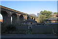
Branksome, railway viaducts
As seen from Gordon Road. In the foreground, the now dismantled line which once led to Bournemouth West station; in the background, the current mainline from Bournemouth to Poole. The viaducts were built in 1884. Local historians say that during construction of the viaducts, a horse and cart carrying bricks fell into the then hollow structure, could not be retrieved, and had to be covered with infill. For a diagram showing what the original layout was, see http://www.sdjr.net/locations/branksome.html
Image: © Mike Faherty
Taken: 23 Jun 2009
0.07 miles
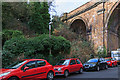
5
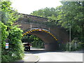
Viaducts, Gordon Road, Poole
The lefthand one carries the main railway line. The righthand one is derelict.
Image: © Peter Facey
Taken: 25 Jan 2007
0.07 miles
6
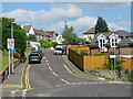
James Road, Branksome, Poole
James Road is a residential road in Branksome, a suburb of Poole. A sign indicates that a 20mph speed limit applies on this road.
Image: © Malc McDonald
Taken: 25 Aug 2021
0.08 miles
7
Branksome: double viaduct
Surrey Road passes under two viaducts in quick succession, though only one now carries track. The near viaduct used to provide rail access to the old Bournemouth West station, which is now a train maintenance depot. The depot is accessed only via the southern 'arm' of the triangle (see map), meaning that this particular viaduct is redundant. The far viaduct carries the mainline between Weymouth and London Waterloo.
Image: © Chris Downer
Taken: 15 Jul 2007
0.09 miles
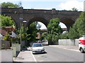
8
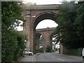
Railway bridge over Bourne Valley Road, Branksome, Poole
An arch bridge carrying the London to Weymouth railway line over Bourne Valley Road in Branksome, a suburb of Poole. Yellow and black markers have been fitted to the bridge as an added warning to drivers that the bridge is low. The triangular sign in the centre of the arch advises that the maximum height for vehicles passing beneath the bridge is 11 feet 6 inches.
Image: © Malc McDonald
Taken: 25 Aug 2021
0.09 miles
9
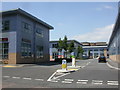
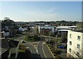
Branksome Business Park
Newly-built, on Bourne Valley Road; http://www.bsbcharteredarchitects.co.uk/branksome-business-park.htm
Image: © Mike Faherty
Taken: 23 Jun 2009
0.09 miles
10
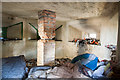
WWII defences in the environs of Bournemouth & Christchurch: Branksome car park - pillbox (3)
-
Pillbox (type FW3/22): DoB ID: e11750
A view of the interior through one of the embrasures. Not sure about the central brick pillar, whether it is a supporting column, or simply a partially dismembered anti-ricochet wall. The latter is normally found complete within a standard type 22.
Image
Image: © Mike Searle
Taken: 4 Mar 2016
0.10 miles