IMAGES TAKEN NEAR TO
Old Christchurch Road, BOURNEMOUTH, BH1 1LL
Introduction
This page details the photographs taken nearby to Old Christchurch Road, BH1 1LL by members of the Geograph project.
The Geograph project started in 2005 with the aim of publishing, organising and preserving representative images for every square kilometre of Great Britain, Ireland and the Isle of Man.

There are currently over 7.5m images from over14,400 individuals and you can help contribute to the project by visiting https://www.geograph.org.uk
Image Map
Images are licensed for reuse under creativecommons.org/licenses/by-sa/2.0
Notes
- Clicking on the map will re-center to the selected point.
- The higher the marker number, the further away the image location is from the centre of the postcode.
Image Listing (1639 Images Found)
Images are licensed for reuse under creativecommons.org/licenses/by-sa/2.0
Image
Details
Distance
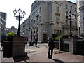
1

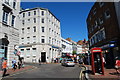
Bournemouth, Old Christchurch Road
One of the town's two pedestrian shopping roads, predominantly Victorian architecturally.
Image: © Mike Faherty
Taken: 21 Aug 2010
0.01 miles
2
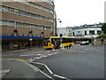
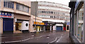
Bournemouth: end of top pedestrianised stretch of Old Christchurch Road
Looking towards the town centre along Old Christchurch Road. Immediately ahead, there is vehicular access between the pedestrianised sections of this road. Oddly, the upper part (behind us) is marked on the 1:50,000 map but the one ahead of us, in the distance, is not shown.
Image: © Chris Downer
Taken: 2 Dec 2010
0.01 miles
3
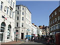
Old Christchurch Road, Bournemouth
Old Christchurch Road in Bournemouth town centre.
Image: © Malc McDonald
Taken: 19 Aug 2012
0.01 miles
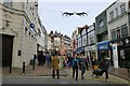
7
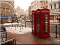
Bournemouth: phone boxes in Old Christchurch Road
A pair of traditional red phone boxes stand by the junction of Yelverton Road (off to the right) and Beale Place (left), which latter is named after Beale's, the department store whose rounded corner we see on the left. The snowfall was a rarity for Bournemouth, as it reached the amazing depths of getting on for an inch!
Image: © Chris Downer
Taken: 6 Jan 2010
0.02 miles
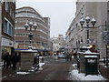
8
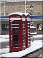
Bournemouth: phone boxes in the snow
Two traditional red telephone boxes stand on the corner of Old Christchurch Road and Beale Place, covered in snow from overnight, which saw Bournemouth's heaviest snowfall for 17 years.
Image: © Chris Downer
Taken: 2 Dec 2010
0.02 miles
9
Bournemouth : Fir Vale Road
Lava Ignite (formerly Elements) nightclub and an estate agents can be seen on this road.
Image: © Lewis Clarke
Taken: 7 Feb 2009
0.02 miles