IMAGES TAKEN NEAR TO
Lorne Park Road, BOURNEMOUTH, BH1 1JP
Introduction
This page details the photographs taken nearby to Lorne Park Road, BH1 1JP by members of the Geograph project.
The Geograph project started in 2005 with the aim of publishing, organising and preserving representative images for every square kilometre of Great Britain, Ireland and the Isle of Man.

There are currently over 7.5m images from over14,400 individuals and you can help contribute to the project by visiting https://www.geograph.org.uk
Image Map
Images are licensed for reuse under creativecommons.org/licenses/by-sa/2.0
Notes
- Clicking on the map will re-center to the selected point.
- The higher the marker number, the further away the image location is from the centre of the postcode.
Image Listing (451 Images Found)
Images are licensed for reuse under creativecommons.org/licenses/by-sa/2.0
Image
Details
Distance
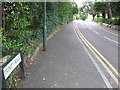
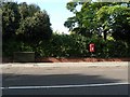
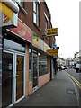
2
Bournemouth: Lorne Park Road
An odd-shaped back street in Bournemouth town centre, which forms an elongated circle with Cumnor Road, the inside circle possessing no pavement (left). The road consists mainly of original houses converted into flats.
In the background is Image, a common background feature within the town when up.
Image: © Chris Downer
Taken: 25 Mar 2016
0.03 miles
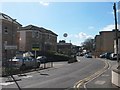
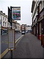
3
Bournemouth: Old Christchurch Road (upper end)
Old Christchurch Road links Image with Image and this is looking down from near the latter. The row of shops in the picture is odd №s 169 to 187; the JobCentre closed on 30 November 2007 and opened in its new purpose-built premises (Image) on 10 December.
Image: © Chris Downer
Taken: 28 Dec 2007
0.05 miles
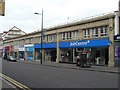
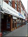
4
Fleet Personnel in Old Christchurch Road
Image: © Basher Eyre
Taken: 20 Aug 2010
0.05 miles
5
Bournemouth: postbox № BH1 401, Madeira Road
A small postbox mounted on a pole.
Image: © Chris Downer
Taken: 20 Sep 2008
0.05 miles
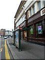
6
Bournemouth: choice of buses on Old Christchurch Road
July 2007 saw a major change in the numbering of Bournemouth's Yellow Buses that had dated back decades, since well before the discontinuation of trams and trolley buses. Each route had previously had its own distinct number, and these were to no evident pattern, perhaps more related to the order in which the routes were introduced.
Now, the main Poole-Christchurch routes are numbered 1, with a, b and c denoting the slightly different route taken by each; these are colour coded in reddish colours. Similarly, the 2s go to Iford and then round the north of the town, with the letter indicating the exact route and colour coded in shades of green. The 3 runs through Charminster to the Hospital; the 4s go through Winton and Moordown with the 4a going west to Bearwood and the 4b east to Muscliff – these are brownish colours. The 5a and 5b serve Winton and then Ensbury Park and Kinson, each taking a slightly different route and these are colour coded in bluish green. The 6a, 6b and 6c serve Winton and Wallisdown. Finally, the low frequency routes, of which only the 24 stops here, are shown in bright red.
A recent improvement in the bus-stop displays is a complete run-down of every bus due to stop there – 478 of them in the Saturday section in the centre of this sheet (Sundays below and continuation of weekdays above, from the other side) – rather than simple listings of frequency for each route.
Image: © Chris Downer
Taken: 31 Dec 2008
0.05 miles
10
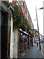
Floral display in Old Christchurch Road
Image: © Basher Eyre
Taken: 20 Aug 2010
0.06 miles