IMAGES TAKEN NEAR TO
King John Avenue, BOURNEMOUTH, BH11 9UW
Introduction
This page details the photographs taken nearby to King John Avenue, BH11 9UW by members of the Geograph project.
The Geograph project started in 2005 with the aim of publishing, organising and preserving representative images for every square kilometre of Great Britain, Ireland and the Isle of Man.

There are currently over 7.5m images from over14,400 individuals and you can help contribute to the project by visiting https://www.geograph.org.uk
Image Map (Loading...)


Getting Data...Please wait
Leaflet Map data © OpenStreetMap
Images are licensed for reuse under creativecommons.org/licenses/by-sa/2.0
Notes
- Clicking on the map will re-center to the selected point.
- The higher the marker number, the further away the image location is from the centre of the postcode.
Image Listing (24 Images Found)
Images are licensed for reuse under creativecommons.org/licenses/by-sa/2.0
Image
Details
Distance
1
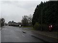
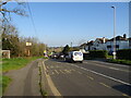
Bearwood: postbox № BH11 287, King John Avenue
The northern end of King John Avenue, the main thoroughfare of the vast 1980s Bearwood estate, which straggles across the Bournemouth/Poole borough boundary. This means that the area is postally in Bournemouth but administratively in Poole.
Since this picture was taken, the postbox has lost its drop box and the trees behind it have been cleared: see Image
Image: © Chris Downer
Taken: 30 Nov 2008
0.06 miles
2
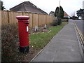
Bearwood: postbox № BH11 287, King John Avenue
This Elizabeth II-reign postbox has seen a couple of changes in the last two or three years. Firstly vegetation including large conifers has been cut down from behind it, and secondly it has been relieved of its drop box - see the box in November 2008 here: Image
The box is emptied finally at 5:30pm on weekdays and at noon on Saturdays.
Image: © Chris Downer
Taken: 23 Jan 2011
0.06 miles

5
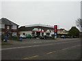
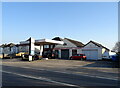
Knighton Garage
On Magna Road, and according to the sign, founded in 1937.
Image: © Mike Faherty
Taken: 21 Jan 2010
0.10 miles
7
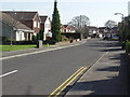
Runnymede Avenue, Bearwood
This development was mostly built in the 1980s.
Image: © mike smith
Taken: 16 Mar 2007
0.11 miles
9
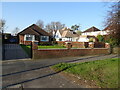
Houses on Magna Rd
These are the last few houses on the north western edge of Bournemouth before open countryside. They back onto fields near Knighton farm and Knighton House. the road in the foreground is the A341, Magna Rd.
Image: © Nigel Mykura
Taken: 15 Nov 2011
0.14 miles
10
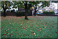
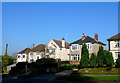
Turf Zone "BaronsZone"
Small green on Barons Road, Bearwood.
Image: © Ian S
Taken: 15 Nov 2022
0.14 miles