IMAGES TAKEN NEAR TO
King Richard Drive, BOURNEMOUTH, BH11 9UF
Introduction
This page details the photographs taken nearby to King Richard Drive, BH11 9UF by members of the Geograph project.
The Geograph project started in 2005 with the aim of publishing, organising and preserving representative images for every square kilometre of Great Britain, Ireland and the Isle of Man.

There are currently over 7.5m images from over14,400 individuals and you can help contribute to the project by visiting https://www.geograph.org.uk
Image Map (Loading...)


Getting Data...Please wait
Leaflet Map data © OpenStreetMap
Images are licensed for reuse under creativecommons.org/licenses/by-sa/2.0
Notes
- Clicking on the map will re-center to the selected point.
- The higher the marker number, the further away the image location is from the centre of the postcode.
Image Listing (8 Images Found)
Images are licensed for reuse under creativecommons.org/licenses/by-sa/2.0
Image
Details
Distance
1
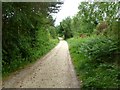
Bearwood, bridleway
A continuation of Wheelers Lane, leading to Canford Heath; housing development out of sight to the left.
Image: © Mike Faherty
Taken: 29 May 2011
0.17 miles
2
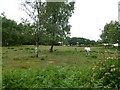
Bearwood, horse grazing
On transitional land, between Canford Heath and housing estates.
Image: © Mike Faherty
Taken: 29 May 2011
0.19 miles
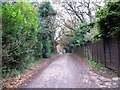
3
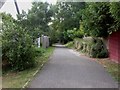
Bearwood, Wheeler's Lane
West of Knights Lane, Image becomes Wheeler's Lane, still a bridleway, though without any evidence of horse riding, winding its way between modern housing development.
Image: © Mike Faherty
Taken: 24 Aug 2009
0.20 miles
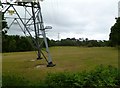
4
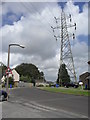
Viscount Walk
Electricity pylons in Bearwood.
Image: © Burgess Von Thunen
Taken: 2 Aug 2012
0.20 miles
5
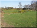
Open Land at Bearwood
Nearly half of this kilometre is still open land.
Image: © mike smith
Taken: 16 Mar 2007
0.21 miles
7
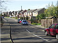
Knights Road, Bearwood
Most of Bearwood is now a sprawling housing development.
Image: © mike smith
Taken: 16 Mar 2007
0.24 miles
8
Bearwood, power lines
Cutting across grazing land; this run seems to go from Knighton to Beacon Heath.
Image: © Mike Faherty
Taken: 29 May 2011
0.25 miles