IMAGES TAKEN NEAR TO
Knights Road, BOURNEMOUTH, BH11 9SU
Introduction
This page details the photographs taken nearby to Knights Road, BH11 9SU by members of the Geograph project.
The Geograph project started in 2005 with the aim of publishing, organising and preserving representative images for every square kilometre of Great Britain, Ireland and the Isle of Man.

There are currently over 7.5m images from over14,400 individuals and you can help contribute to the project by visiting https://www.geograph.org.uk
Image Map
Images are licensed for reuse under creativecommons.org/licenses/by-sa/2.0
Notes
- Clicking on the map will re-center to the selected point.
- The higher the marker number, the further away the image location is from the centre of the postcode.
Image Listing (33 Images Found)
Images are licensed for reuse under creativecommons.org/licenses/by-sa/2.0
Image
Details
Distance
1
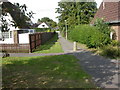
Bearwood, footpath
Footpath between Runnymede Avenue & Magna Road; not recognised as a right of way by OS.
Image: © Mike Faherty
Taken: 24 Aug 2009
0.04 miles
2
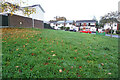
Turf Zone "RunnyNose"
On Runnymede Avenue, Bearwood.
Image: © Ian S
Taken: 15 Nov 2022
0.04 miles
3
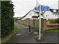
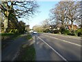
Shared path, Bearwood, near Bournemouth
A path for pedestrians and cyclists in Bearwood, on the northern outskirts of Bournemouth. The signpost in the foreground indicates that the path forms part of a network of cycle routes in Bournemouth and the surrounding area.
Image: © Malc McDonald
Taken: 9 Feb 2025
0.09 miles
4
Bearwood, Charter Road
Modern, individualised houses along Charter Road.
Image: © Mike Faherty
Taken: 24 Aug 2009
0.09 miles
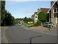
5
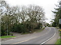
Magna Road, Bearwood, near Bournemouth
Magna Road forms part of the route of the A341 through Bearwood, on the northern outskirts of Bournemouth.
Image: © Malc McDonald
Taken: 9 Feb 2025
0.09 miles
7
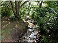
Bearwood, stream
A stream that appears to join the River Stour near Longham (though it might be culverted to the North of here), providing a linear, tree-lined break between modern housing developments.
Image: © Mike Faherty
Taken: 24 Aug 2009
0.12 miles
9
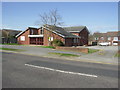
St Barnabas Church
The church was built in the 1980s along with the housing estate.
Image: © mike smith
Taken: 16 Mar 2007
0.13 miles
10
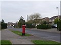
Bearwood: postbox № BH11 397, King John Avenue
This postbox is close to the 'centre' of Bearwood if there is one – by the community centre and supermarket, and outside St. Barnabas' church.
Image: © Chris Downer
Taken: 4 Jan 2009
0.13 miles