IMAGES TAKEN NEAR TO
Barons Road, BOURNEMOUTH, BH11 9RP
Introduction
This page details the photographs taken nearby to Barons Road, BH11 9RP by members of the Geograph project.
The Geograph project started in 2005 with the aim of publishing, organising and preserving representative images for every square kilometre of Great Britain, Ireland and the Isle of Man.

There are currently over 7.5m images from over14,400 individuals and you can help contribute to the project by visiting https://www.geograph.org.uk
Image Map
Images are licensed for reuse under creativecommons.org/licenses/by-sa/2.0
Notes
- Clicking on the map will re-center to the selected point.
- The higher the marker number, the further away the image location is from the centre of the postcode.
Image Listing (31 Images Found)
Images are licensed for reuse under creativecommons.org/licenses/by-sa/2.0
Image
Details
Distance
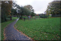
1
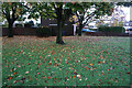
Turf Zone "BaronsZone"
Small green on Barons Road, Bearwood.
Image: © Ian S
Taken: 15 Nov 2022
0.03 miles
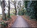
5
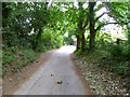
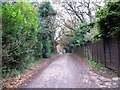
Bearwood, Wheelers Lane
Lane and bridleway, from Magna Road to Knights Road.
Image: © Mike Faherty
Taken: 29 May 2011
0.12 miles
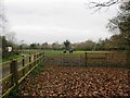
6
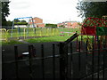
Bearwood, play area
Charter Road Play Area, next to Image
Image: © Mike Faherty
Taken: 24 Aug 2009
0.14 miles
7
Turf Zone "Bearwood"
Park off King John Avenue, Bearwood.
Image: © Ian S
Taken: 15 Nov 2022
0.15 miles
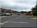
8
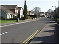
Runnymede Avenue, Bearwood
This development was mostly built in the 1980s.
Image: © mike smith
Taken: 16 Mar 2007
0.15 miles
10
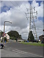
Viscount Walk
Electricity pylons in Bearwood.
Image: © Burgess Von Thunen
Taken: 2 Aug 2012
0.15 miles