IMAGES TAKEN NEAR TO
Coniston Avenue, BOURNEMOUTH, BH11 9NN
Introduction
This page details the photographs taken nearby to Coniston Avenue, BH11 9NN by members of the Geograph project.
The Geograph project started in 2005 with the aim of publishing, organising and preserving representative images for every square kilometre of Great Britain, Ireland and the Isle of Man.

There are currently over 7.5m images from over14,400 individuals and you can help contribute to the project by visiting https://www.geograph.org.uk
Image Map
Images are licensed for reuse under creativecommons.org/licenses/by-sa/2.0
Notes
- Clicking on the map will re-center to the selected point.
- The higher the marker number, the further away the image location is from the centre of the postcode.
Image Listing (68 Images Found)
Images are licensed for reuse under creativecommons.org/licenses/by-sa/2.0
Image
Details
Distance
1
Break Time
Shapland Avenue in Bear Cross.
Image: © Burgess Von Thunen
Taken: 21 Mar 2012
0.04 miles
2
Turf Zone "WellDone"
On Snaplands Avenue, Bearwood.
Image: © Ian S
Taken: 15 Nov 2022
0.05 miles
3
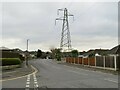
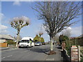
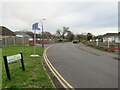
Shapland Avenue, Bearwood
Shapland Avenue is a residential road in Bearwood, in the northern outskirts of Bournemouth. An electricity pylon stands tall over the road.
Image: © Malc McDonald
Taken: 9 Feb 2025
0.06 miles
4
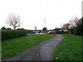
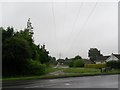
Bear Cross: footpath E03 approaches Magna Road
This public footpath joins the main A341 Magna Road, along which we see a small red van travelling, with Bear Cross Avenue behind us. It meanders through a grass clearing between the houses, coinciding with the course of overhead power lines.
See Image for the view towards us from the roadside ahead, and Image for the view behind us, with links to further photos along this and a continuing footpath.
Image: © Chris Downer
Taken: 7 Jan 2017
0.08 miles
5
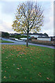
Finchfield Avenue, Bear Cross, near Bournemouth
Finchfield Avenue is a residential road in Bear Cross, on the northern outskirts of Bournemouth. The housing here comprises bungalows.
The signpost to the side of the road indicates a number of destinations which can be reached by bicycle, thus indicating that Finchfield Avenue forms part of a network of cycling routes in Bournemouth and the surrounding area.
Image: © Malc McDonald
Taken: 9 Feb 2025
0.08 miles
6
Bear Cross: footpath E31 from Magna Road
This short public footpath (13 metres in length) is really just a natural connecting path between the pavements of Magna Road (foreground) and Finchfield Avenue, which heads left from here at a 45° angle to Magna Road.
The roads do not meet to our immediate right; Finchfield Avenue becomes a service road for a couple of hundred metres, running parallel with Magna Road and with the grass separation continuing.
See Image for the view along the path from the other end.
Image: © Chris Downer
Taken: 7 Jan 2017
0.09 miles
7
Bear Cross: footpath E31 between Finchfield Avenue and Magna Road
This short public footpath (13 metres in length) is really just a natural connecting path between the pavements of Magna Road (background) and Finchfield Avenue, which heads right from here at a 45° angle to Magna Road.
The roads do not meet to our immediate left; Finchfield Avenue becomes a service road for a couple of hundred metres, running parallel with Magna Road and with the grass separation continuing.
See Image for the view along the path from the other end.
Image: © Chris Downer
Taken: 28 Jun 2016
0.09 miles
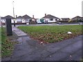
8
Bear Cross: Fulwood Avenue shops
A small parade of shops which has no doubt thrived more in years gone by; it includes a newsagent on the far corner, a dental practice and a couple of vacant looking premises this end.
Image: © Chris Downer
Taken: 4 Jan 2009
0.09 miles
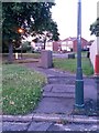
9
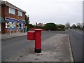
Bear Cross: postbox № BH11 78, Fulwood Avenue
This postbox is outside Image Despite the possible suggestion, there was never a post office here.
Image: © Chris Downer
Taken: 4 Jan 2009
0.09 miles
10
Bear Cross: footpath E03 from across Magna Road
Looking across the main A348 Magna Road along this path to Bear Cross Avenue. Its course, through a clearing between the houses, coincides with the path of overhead power lines, including through to another path beyond.
See Image for a closer view of the path, viewed from opposite.
Image: © Chris Downer
Taken: 26 Jun 2016
0.09 miles