IMAGES TAKEN NEAR TO
Ringwood Road, BOURNEMOUTH, BH11 9LQ
Introduction
This page details the photographs taken nearby to Ringwood Road, BH11 9LQ by members of the Geograph project.
The Geograph project started in 2005 with the aim of publishing, organising and preserving representative images for every square kilometre of Great Britain, Ireland and the Isle of Man.

There are currently over 7.5m images from over14,400 individuals and you can help contribute to the project by visiting https://www.geograph.org.uk
Image Map (Loading...)


Getting Data...Please wait
Leaflet Map data © OpenStreetMap
Images are licensed for reuse under creativecommons.org/licenses/by-sa/2.0
Notes
- Clicking on the map will re-center to the selected point.
- The higher the marker number, the further away the image location is from the centre of the postcode.
Image Listing (66 Images Found)
Images are licensed for reuse under creativecommons.org/licenses/by-sa/2.0
Image
Details
Distance
1

Bear Cross: 1200-1202 Ringwood Road
These are the highest house numbers in Ringwood Road - although the road continues over Longham Bridge, it leaves the borough of Bournemouth and the numbering, which commence several miles away in the centre of Poole, restarts.
Today, these premises have been the victim of flooding as the River Stour, just behind them, burst its banks earlier in the day. The doors are barricaded with sandbags in the hope that their interiors are spared the same fate as their gardens.
Image: © Chris Downer
Taken: 9 Jul 2012
0.02 miles
2
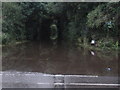
Kinson: Millhams Road is underwater
Looking along Millhams Road from Ringwood Road, which have both been closed almost all day after the River Stour burst its banks midmorning.
The council's rubbish dump, just down this lane, has been closed all day too, unsurprisingly as this is the only means of access to it.
Image: © Chris Downer
Taken: 9 Jul 2012
0.03 miles
3
Longham area
Longham Waterworks pipeline
Image: © Peter Elsdon
Taken: 15 Nov 2009
0.04 miles
4
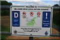
Nature reserve sign
On a gate near Longham Bridge.
Image: © David Lally
Taken: 18 Sep 2010
0.04 miles
5
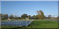
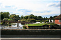
Longham Bridge & River Stour
Longham Bridge was built in 1728, widened in 1792, and the cantilevered footpath added in about 1960. As seen from the river bank, looking upstream. Yellow coats belong to two surveyors. For a view of the bridge at road level, see Image
Image: © Mike Faherty
Taken: 19 Feb 2009
0.05 miles
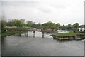
6
Weirs on the River Stour
From Longham Bridge.
Image: © David Lally
Taken: 18 Sep 2010
0.05 miles
8
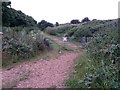
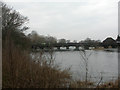
Kinson: the Stour Valley Way and footpath E28 leave Ringwood Road
Looking along a gravel track from the corner of Ringwood Road by Longham Bridge. This forms part of the Stour Valley Way, a long-distance path based on the River Stour which is just alongside us. It meanders alongside a big bend in a minor tributary of the Stour.
Starting at this point is public footpath E28, which takes a more direct route to Millhams Road, over a lump of grassland. See Image for the next picture and discussion of the exact route of the public right of way.
Image: © Chris Downer
Taken: 29 Jun 2016
0.05 miles
10
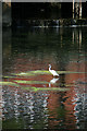
Little egret (Egretta garzetta) on the River Stour
Upstream of Longham Bridge beside the waterworks.
The little egret doesn't feature at all in the bird books from my childhood birdwatching days in the mid to late 1960s, except perhaps as a footnote as a very rare sighting. Now relatively common as a breeding bird along the rivers of the south coast. The RSPB currently give the numbers as 146 - 162 breeding pairs with 1,600 winter visitors.
A few weeks after I took this some updated numbers were given on the forum http://www.geograph.org.uk/discuss/index.php?&action=vthread&forum=6&topic=12546&dontcount=1&page=0#1 .
Image: © David Lally
Taken: 18 Sep 2010
0.06 miles