IMAGES TAKEN NEAR TO
High Oaks Gardens, BOURNEMOUTH, BH11 9LJ
Introduction
This page details the photographs taken nearby to High Oaks Gardens, BH11 9LJ by members of the Geograph project.
The Geograph project started in 2005 with the aim of publishing, organising and preserving representative images for every square kilometre of Great Britain, Ireland and the Isle of Man.

There are currently over 7.5m images from over14,400 individuals and you can help contribute to the project by visiting https://www.geograph.org.uk
Image Map (Loading...)


Getting Data...Please wait
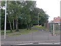
Leaflet Map data © OpenStreetMap
Images are licensed for reuse under creativecommons.org/licenses/by-sa/2.0
Notes
- Clicking on the map will re-center to the selected point.
- The higher the marker number, the further away the image location is from the centre of the postcode.
Image Listing (62 Images Found)
Images are licensed for reuse under creativecommons.org/licenses/by-sa/2.0
Image
Details
Distance
1
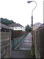
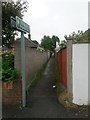
West Howe: a quick kink in footpath U09
Looking along this public footpath as it approaches Ringwood Road. The path does a very quick left-right before running alongside a driveway.
See Image for a picture looking towards us from ahead, and Image for a view up the path from the end behind us.
Image: © Chris Downer
Taken: 26 Jun 2016
0.04 miles
2
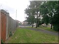
West Howe: footpath U09 heads for High Howe Lane
Looking down this public footpath, which is separated from a driveway by railings.
See Image for a view towards us from just past the double bend, and Image for a view along the path from behind us.
Image: © Chris Downer
Taken: 26 Jun 2016
0.04 miles
3

Bournemouth : ITW Finishing UK
ITW Industrial Finishing Europe based in Bournemouth, England, Dietzenbach,Germany and Valence, France manufacture all types of Industrial Spray Finishing Equipment and accessories.
Image: © Lewis Clarke
Taken: 8 Mar 2010
0.04 miles
4

Bournemouth : ITW Finishing UK
Incorporating the world leading brands of Binks Devilbiss Ransburg produce high technology Spray Finishing equipment for the supply and application of all sprayed materials for all major manufacturing Industries and Markets.
Image: © Lewis Clarke
Taken: 8 Mar 2010
0.05 miles
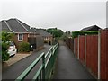
5
Bournemouth : Oakmead Gardens Footpath
This footpath connects Poole Lane with Ringwood Road passing housing on Oakmead Gardens.
Image: © Lewis Clarke
Taken: 8 Mar 2010
0.05 miles
6
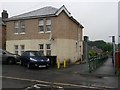
West Howe: former post office and footpath U09 to High Howe Lane
Recognisably a former shop thanks to the shaved-off corner where the door was, 980 Ringwood Road was West Howe Post Office until its closure in 2004.
Alongside it, we see a public footpath leading through to High Howe Lane - see Image for a photo a little further down the path.
Image: © Chris Downer
Taken: 26 Jun 2016
0.05 miles
7

Bournemouth : Ringwood Road A348
Ringwood Road as it approaches Poole Lane Roundabout, and Poole itself.
Image: © Lewis Clarke
Taken: 8 Mar 2010
0.05 miles
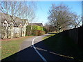
8
West Howe: footpath U10 from Ringwood Road
Looking across the southbound carriageway of the busy A348 Ringwood Road, along this public footpath which has changed course in recent years.
The original course of the path was the dead-straight run abutting the fence on the right (still followable today), but with the recent development Oakmead Gardens being built, a paved, shared foot/cycle path has been installed and the public right of way is shown as that meandering route on recent right of way maps.
See Image for the view towards us from a little way along the path, and links to further photos on the route.
Image: © Chris Downer
Taken: 17 Jul 2016
0.05 miles
9
West Howe: footpath U09 to Ringwood Road
A public footpath 114 metres in length, perfectly straight but for the very minor double bend about two thirds of the way along - see Image
Image: © Chris Downer
Taken: 26 Jun 2016
0.06 miles
10
West Howe: footpath U10 approaches Ringwood Road
Looking towards the busy A348 Ringwood Road, along this public footpath which has changed course in recent years.
The original course of the path was a dead-straight run abutting the fence on the left (still followable today), but with the recent development Oakmead Gardens being built, a paved, shared foot/cycle path has been installed and the public right of way is shown as that meandering route on recent right of way maps.
See Image for the view towards us from across the road, and Image for the next view on the path behind us, and links to further photos on the route.
Image: © Chris Downer
Taken: 17 Jul 2016
0.06 miles