IMAGES TAKEN NEAR TO
Poitiers Drive, BH11 9GG
Introduction
This page details the photographs taken nearby to Poitiers Drive, BH11 9GG by members of the Geograph project.
The Geograph project started in 2005 with the aim of publishing, organising and preserving representative images for every square kilometre of Great Britain, Ireland and the Isle of Man.

There are currently over 7.5m images from over14,400 individuals and you can help contribute to the project by visiting https://www.geograph.org.uk
Image Map (Loading...)


Getting Data...Please wait
Leaflet Map data © OpenStreetMap
Images are licensed for reuse under creativecommons.org/licenses/by-sa/2.0
Notes
- Clicking on the map will re-center to the selected point.
- The higher the marker number, the further away the image location is from the centre of the postcode.
Image Listing (9 Images Found)
Images are licensed for reuse under creativecommons.org/licenses/by-sa/2.0
Image
Details
Distance
1
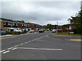
Merton Grange
Merton Grange stands on the western side of the Bearwood housing development.
Image: © Peter Kazmierczak
Taken: 23 May 2010
0.06 miles
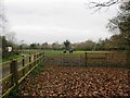
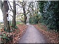
3
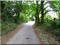
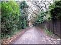
Bearwood, Wheelers Lane
Lane and bridleway, from Magna Road to Knights Road.
Image: © Mike Faherty
Taken: 29 May 2011
0.10 miles
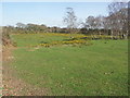
7
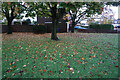
Turf Zone "BaronsZone"
Small green on Barons Road, Bearwood.
Image: © Ian S
Taken: 15 Nov 2022
0.15 miles
8
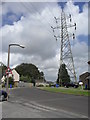
Viscount Walk
Electricity pylons in Bearwood.
Image: © Burgess Von Thunen
Taken: 2 Aug 2012
0.16 miles
9
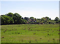
Open Land at Bearwood
Nearly half of this kilometre is still open land.
Image: © mike smith
Taken: 16 Mar 2007
0.25 miles