IMAGES TAKEN NEAR TO
Garsdale Close, BOURNEMOUTH, BH11 9DN
Introduction
This page details the photographs taken nearby to Garsdale Close, BH11 9DN by members of the Geograph project.
The Geograph project started in 2005 with the aim of publishing, organising and preserving representative images for every square kilometre of Great Britain, Ireland and the Isle of Man.

There are currently over 7.5m images from over14,400 individuals and you can help contribute to the project by visiting https://www.geograph.org.uk
Image Map (Loading...)


Getting Data...Please wait
Leaflet Map data © OpenStreetMap
Images are licensed for reuse under creativecommons.org/licenses/by-sa/2.0
Notes
- Clicking on the map will re-center to the selected point.
- The higher the marker number, the further away the image location is from the centre of the postcode.
Image Listing (77 Images Found)
Images are licensed for reuse under creativecommons.org/licenses/by-sa/2.0
Image
Details
Distance
1
NEW
Durdells Avenue, Kinson, near Bournemouth
Durdells Avenue is a residential road in Kinson, in the northern outskirts of Bournemouth. Signs indicate that a speed limit of 20 miles per hour applies on this road.
Image: © Malc McDonald
Taken: 9 Feb 2025
0.04 miles
2
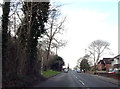
Bournemouth's longest road
Wimborne Road extends from the top of Richmond Hill to Bear Cross roundabout and is the longest in Bournemouth.
Image: © Peter Kazmierczak
Taken: 5 Mar 2016
0.05 miles
3
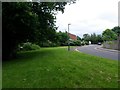
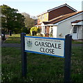
Kinson: Garsdale Close and Millhams Mead
Garsdale Close is a small cul-de-sac off the main Wimborne Road and alongside it is an entrance to Millhams Mead local nature reserve, a narrow wood and grassland area abutting a minor course of the River Stour.
Image: © Chris Downer
Taken: 30 Jun 2016
0.05 miles
4
NEW
Anstey Road, Kinson
Anstey Road is a residential road in Kinson, in the northern outskirts of Bournemouth.
Image: © Malc McDonald
Taken: 9 Feb 2025
0.05 miles
5
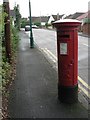
Kinson: postbox № BH11 79, Durdells Avenue
Looking along Durdells Avenue from its northern end, past this George VI-reign postbox.
Image: © Chris Downer
Taken: 31 Aug 2008
0.06 miles
6
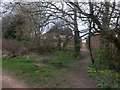
Kinson: towards footpath E22 from Millhams Mead
We look west from the entrance to Millhams Mead local nature reserve (see Image). Beyond the trees is a short public footpath accessing Cudnell Avenue.
See Image for the entrance to the path, at the rear garden fences.
Image: © Chris Downer
Taken: 18 Mar 2017
0.06 miles
7
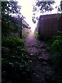
Kinson: along footpath E22 from Millhams Mead
Looking west from darkly under a tree, towards the start of a public footpath to Cudnell Avenue.
See Image for a wider view from behind us, and Image] for a view towards us from a little way up the path.
Image: © Chris Downer
Taken: 30 Jun 2016
0.06 miles
8
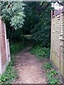
Kinson: footpath E22 enters Millhams Mead
The short Image reaches its journey's end as it opens out into the Millhams Mead local nature reserve (Image]).
See Image for a rather dark view back towards us, and Image for the view behind us onto Cudnell Avenue.
Image: © Chris Downer
Taken: 30 Jun 2016
0.06 miles
9
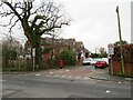
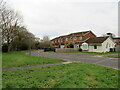
Bear Cross: Garsdale Close
This cul-de-sac off the main Wimborne Road curves immediately around to the right and has a couple of rows of houses facing each other across a footpath coming back out on the main road a bit further down.
It also provides access, by the big tree in the background, into Millhams Mead Local Nature Reserve (see Image).
The road sign is a standard one from around 2000-2006, perhaps a little earlier, featuring the borough coat of arms.
This is photo no.156 of a series of 453 in my coronavirus lockdown walking project:
See https://www.geograph.org.uk/article/My-2020-Coronavirus-Lockdown-walking-project for the complete set of photos.
Image: © Chris Downer
Taken: 16 Apr 2020
0.06 miles
10
NEW
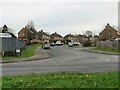
Garsdale Close, Kinson, near Bournemouth
Garsdale Close is a residential cul-de-sac in Kinson, in the northern outskirts of Bournemouth.
Image: © Malc McDonald
Taken: 9 Feb 2025
0.06 miles