IMAGES TAKEN NEAR TO
School Lane, BOURNEMOUTH, BH11 9DG
Introduction
This page details the photographs taken nearby to School Lane, BH11 9DG by members of the Geograph project.
The Geograph project started in 2005 with the aim of publishing, organising and preserving representative images for every square kilometre of Great Britain, Ireland and the Isle of Man.

There are currently over 7.5m images from over14,400 individuals and you can help contribute to the project by visiting https://www.geograph.org.uk
Image Map
Images are licensed for reuse under creativecommons.org/licenses/by-sa/2.0
Notes
- Clicking on the map will re-center to the selected point.
- The higher the marker number, the further away the image location is from the centre of the postcode.
Image Listing (118 Images Found)
Images are licensed for reuse under creativecommons.org/licenses/by-sa/2.0
Image
Details
Distance
1
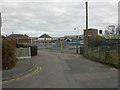
Kinson Primary School
Appropriately, in School Lane. For more information, see http://www.kinsonprimaryschool.ik.org/ For a picture of an earlier version of the school, visit http://www.communigate.co.uk/dorset/kinsondorset/page25.phtml
Image: © Mike Faherty
Taken: 28 Feb 2009
0.03 miles
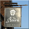
4
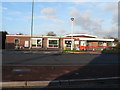
Kinson, Gulliver's Tavern
Straight bar, with sitting areas to left & in front, and games room to right. Logs in fire, unlit; board offering sandwiches, "We don't do food"; 2 beer engines, but no cask ale. Named after smuggler Isaac Gulliver, who lived locally; for his biography, see http://www.communigate.co.uk/dorset/kinsondorset/page3.phtml
Image: © Mike Faherty
Taken: 6 Jan 2009
0.05 miles
5
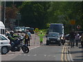
Kinson: lollipop lady on Kinson Road
Looking along Kinson Road from the centre of Kinson, at school finishing time.
Image: © Chris Downer
Taken: 15 May 2014
0.06 miles
6
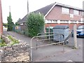
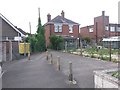
Kinson: footpath E54 to Bramley Road
This short public footpath offers a route from Bramley Road to Kinson Road and is therefore a convenient route to the centre of Kinson. It is seen here from the Kinson Road end.
Alongside the path is Kinson Road Medical Centre.
See Image for a view of the path from the other end.
Image: © Chris Downer
Taken: 14 Jun 2016
0.06 miles
7
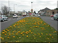
Kinson, crocuses
A colourful display of yellow crocuses in the central reservation of Wimborne Road, Kinson. As seen looking East, towards Ensbury.
Image: © Mike Faherty
Taken: 28 Feb 2009
0.06 miles
8
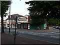
Kinson: post office
The post office is at the western end of the main shopping area of Kinson, at 1518 Wimborne Road.
Image: © Chris Downer
Taken: 21 Jul 2008
0.07 miles
9
Kinson: the old library
Kinson's library has recently closed and is to be replaced by a brand new library/neighbourhood centre complex. It is right in the centre of Kinson, by the green.
See Image for the replacement building.
Image: © Chris Downer
Taken: 23 Nov 2008
0.07 miles
10
Kinson: footpath E54 from Bramley Road
This short public footpath offers a route from Bramley Road to Kinson Road and is therefore a convenient route to the centre of Kinson. It is seen here from the Bramley Road end.
See Image for a view of the path from the other end.
Image: © Chris Downer
Taken: 14 Jun 2016
0.07 miles