IMAGES TAKEN NEAR TO
Cudnell Avenue, BOURNEMOUTH, BH11 9DA
Introduction
This page details the photographs taken nearby to Cudnell Avenue, BH11 9DA by members of the Geograph project.
The Geograph project started in 2005 with the aim of publishing, organising and preserving representative images for every square kilometre of Great Britain, Ireland and the Isle of Man.

There are currently over 7.5m images from over14,400 individuals and you can help contribute to the project by visiting https://www.geograph.org.uk
Image Map (Loading...)


Getting Data...Please wait
Leaflet Map data © OpenStreetMap
Images are licensed for reuse under creativecommons.org/licenses/by-sa/2.0
Notes
- Clicking on the map will re-center to the selected point.
- The higher the marker number, the further away the image location is from the centre of the postcode.
Image Listing (80 Images Found)
Images are licensed for reuse under creativecommons.org/licenses/by-sa/2.0
Image
Details
Distance
1
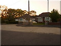
Bear Cross: Bournemouth?s highest house numbers
Wimborne Road, which starts a good few miles southwest in the town centre, approaches its end at Bear Cross Roundabout. Set back from the main carriageway via a parallel service road, the last row of bungalows ends with these two, numbers 1821 and 1823. On the other side, the even numbers reach only 1716.
Image: © Chris Downer
Taken: 19 May 2010
0.07 miles
2

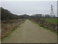
Bear Cross: footpath E07 from Ringwood Road
This public footpath forms part of the Stour Valley Way and is seen here leaving Ringwood Road. It is just over 350m in length and terminates at the borough boundary, where it becomes footpath 112 under Poole Borough Council.
See Image for the next view along the path.
Image: © Chris Downer
Taken: 10 Jul 2016
0.07 miles
3

Bear Cross: approaching Ringwood Road on footpath E07
This public footpath is one of the few truly rural rights of way in the borough of Bournemouth, and forms part of the Stour Valley Way. This is the reverse view to Image The path is just over 350m in length and terminates at the borough boundary, where it becomes footpath 112 under Poole Borough Council.
See Image for the next view along the path behind us.
Image: © Chris Downer
Taken: 10 Jul 2016
0.08 miles
4

Bear Cross: two gates on footpath E07
This public footpath is one of the few truly rural rights of way in the borough of Bournemouth, and forms part of the Stour Valley Way. On leaving Ringwood Road, we almost immediately pass through two gates before proceeding along the track. It is just over 350m in length and terminates at the borough boundary, where it becomes footpath 112 under Poole Borough Council.
See Image for the view towards us from along the path ahead, and Image for the next view onto the path from behind us.
Image: © Chris Downer
Taken: 10 Jul 2016
0.08 miles
5

Bear Cross: Looking along the flooded Stour Valley Way
Another look (see Image) along the discernible but impassable course of the Stour Valley Way as it skirts around the northern edge of Bearwood.
Image: © Chris Downer
Taken: 9 Jul 2012
0.08 miles
6

Bear Cross: a flooded Stour Valley Way
The sign asks walkers to keep to the track, whose course is eminently visible here but it is impassable thanks to the flooding of the River Stour. Heavy rain over the weekend has caused havoc across parts of Dorset and this Bournemouth area was spared the most severe damage.
Image: © Chris Downer
Taken: 9 Jul 2012
0.08 miles
7
Bear Cross, Stour Valley Way
Just inside Bournemouth, this section of the Way is a permissive path, part of the 64 mile path from Christchurch in Dorset to Stour Head in Wiltshire.
Image: © Mike Faherty
Taken: 21 Jan 2010
0.09 miles
8
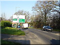
Wimborne Road (A341) approaching roundabout
Image: © JThomas
Taken: 24 Mar 2022
0.09 miles
9
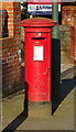
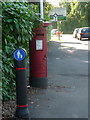
George VI postbox on Wimborne Road
Postbox No. BH11 336.
Image: © JThomas
Taken: 24 Mar 2022
0.10 miles
10
Bear Cross: a postbox has a change of scenery
Since I photographed Image, many changes have taken place to its immediate surroundings.
A pedestrian crossing has been installed directly next to us, and the pavement designated a shared foot/cycle path. To achieve the wider surface required for this, the grass edge has been removed and the postbox now stands directly on tarmac.
The roundabout direction sign, which had stood directly in front of the postbox, has now been moved back a few yards and is visible in the distance. A lamppost has also been re-sited against the premises wall.
Image: © Chris Downer
Taken: 12 Jun 2014
0.10 miles