IMAGES TAKEN NEAR TO
Wimborne Road, BOURNEMOUTH, BH11 9AY
Introduction
This page details the photographs taken nearby to Wimborne Road, BH11 9AY by members of the Geograph project.
The Geograph project started in 2005 with the aim of publishing, organising and preserving representative images for every square kilometre of Great Britain, Ireland and the Isle of Man.

There are currently over 7.5m images from over14,400 individuals and you can help contribute to the project by visiting https://www.geograph.org.uk
Image Map (Loading...)


Getting Data...Please wait
Leaflet Map data © OpenStreetMap
Images are licensed for reuse under creativecommons.org/licenses/by-sa/2.0
Notes
- Clicking on the map will re-center to the selected point.
- The higher the marker number, the further away the image location is from the centre of the postcode.
Image Listing (107 Images Found)
Images are licensed for reuse under creativecommons.org/licenses/by-sa/2.0
Image
Details
Distance
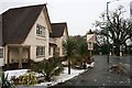
1
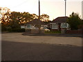
Bear Cross: Bournemouth?s highest house numbers
Wimborne Road, which starts a good few miles southwest in the town centre, approaches its end at Bear Cross Roundabout. Set back from the main carriageway via a parallel service road, the last row of bungalows ends with these two, numbers 1821 and 1823. On the other side, the even numbers reach only 1716.
Image: © Chris Downer
Taken: 19 May 2010
0.01 miles
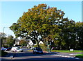
2
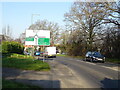
Wimborne Road (A341) approaching roundabout
Image: © JThomas
Taken: 24 Mar 2022
0.04 miles
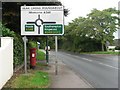
3
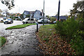
Turf Zone "Wimborne"
On Wimborne Road, Bear Cross.
Image: © Ian S
Taken: 15 Nov 2022
0.06 miles
4
Bear Cross: a postbox has a change of scenery
Since I photographed Image, many changes have taken place to its immediate surroundings.
A pedestrian crossing has been installed directly next to us, and the pavement designated a shared foot/cycle path. To achieve the wider surface required for this, the grass edge has been removed and the postbox now stands directly on tarmac.
The roundabout direction sign, which had stood directly in front of the postbox, has now been moved back a few yards and is visible in the distance. A lamppost has also been re-sited against the premises wall.
Image: © Chris Downer
Taken: 12 Jun 2014
0.06 miles
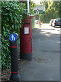
5
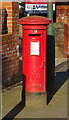
George VI postbox on Wimborne Road
Postbox No. BH11 336.
Image: © JThomas
Taken: 24 Mar 2022
0.06 miles
6

Bear Cross: filling station on Ringwood Road
This filling station, incorporating a grocery store and open 24 hours a day, will have had probably its poorest day's trade today - not because the pumps are dry but because the road is wet.
The River Stour at Longham Bridge, half a mile or so behind us, burst its banks midmorning and the A348 had been close all day, from Bear Cross Roundabout just ahead of us.
Image: © Chris Downer
Taken: 9 Jul 2012
0.07 miles
7
Bear Cross: postbox № BH11 336, Wimborne Road
This George VI-reign postbox is near the end of Wimborne Road - outside number 1700. These are the highest house numbers for miles around, reaching 1714 on this side and 1823 on the other.
Image: © Chris Downer
Taken: 31 Aug 2008
0.07 miles
8
Bear Cross
This has been an important junction for hundreds of years. It is where the A341 Wimborne Road crosses the A348 Ringwood Road. Its name comes from Beare and before that Bearu meaning wooded.
Image: © Nigel Mykura
Taken: 15 Nov 2011
0.07 miles
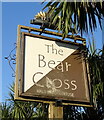
10
The Bear Cross
Had a make-over since the last photo of it was submitted: Image
Image: © David Lally
Taken: 6 Jan 2010
0.08 miles