IMAGES TAKEN NEAR TO
Widget Close, BOURNEMOUTH, BH11 8TE
Introduction
This page details the photographs taken nearby to Widget Close, BH11 8TE by members of the Geograph project.
The Geograph project started in 2005 with the aim of publishing, organising and preserving representative images for every square kilometre of Great Britain, Ireland and the Isle of Man.

There are currently over 7.5m images from over14,400 individuals and you can help contribute to the project by visiting https://www.geograph.org.uk
Image Map (Loading...)


Getting Data...Please wait
Leaflet Map data © OpenStreetMap
Images are licensed for reuse under creativecommons.org/licenses/by-sa/2.0
Notes
- Clicking on the map will re-center to the selected point.
- The higher the marker number, the further away the image location is from the centre of the postcode.
Image Listing (87 Images Found)
Images are licensed for reuse under creativecommons.org/licenses/by-sa/2.0
Image
Details
Distance
1
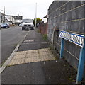
East Howe: Caroline Road
Looking along this short road of bungalows from its western end.
The road sign is a one-line version of the blue design which became prevalent in Bournemouth around 1990 and was in use for most of that decade. These narrower signs are much less common, even for road names that fit nicely on one line! (See Image for one neatly arranged on two lines, and Image for one written on one line but on a larger sign.)
Just beyond it is a concrete pillar shaped to a narrow 'T' at the top, which would undoubtedly originally have displayed an original cast-iron nameplate such as at Image
This is photo no.60 of a series of 453 in my coronavirus lockdown walking project:
See https://www.geograph.org.uk/article/My-2020-Coronavirus-Lockdown-walking-project for the complete set of photos.
Image: © Chris Downer
Taken: 18 Apr 2020
0.04 miles
2
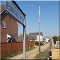
East Howe: Edward Road
This is a funny little road - from the main Kinson Road, the first segment is of gravel - but further down it becomes a properly tarmacked road with pavements.
The sign is a fairly recent one, since about 2015 when the council ditched the logo and instead wrote the name of the council at the top of the sign. This one is double-sided, mounted on a tall pole.
This is photo no.125 of a series of 453 in my coronavirus lockdown walking project:
See https://www.geograph.org.uk/article/My-2020-Coronavirus-Lockdown-walking-project for the complete set of photos.
Image: © Chris Downer
Taken: 11 Apr 2020
0.04 miles
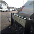
3
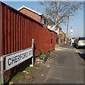
East Howe: Cherford Road
Looking along this traditional suburban side-road, which comes to a dead end at the side of the Fernheath Valley local nature reserve, with access into it on foot.
The sign is the standard Bournemouth nameplate from the 1980s, affixed with tubular steel which protrudes at each side. The empty post just beyond the sign would originally have had a full-size no-through road sign on it, a common alternative to having the no-through road sign incorporated into the nameplate (as at Image).
This is photo no.69 of a series of 453 in my coronavirus lockdown walking project:
See https://www.geograph.org.uk/article/My-2020-Coronavirus-Lockdown-walking-project for the complete set of photos.
Image: © Chris Downer
Taken: 11 Apr 2020
0.07 miles
4
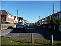
Bournemouth : Cherford Road
Another road leading to a close is Cherford Road, which heads back towards Kinson Road.
Image: © Lewis Clarke
Taken: 8 Mar 2010
0.08 miles
5
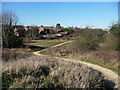
Bournemouth : Fernheath Valley
Fernheath Valley is part of - but detached from - Turbary Common.
Image: © Lewis Clarke
Taken: 8 Mar 2010
0.08 miles
6
East Howe: Heaton Road
A no-through road off Kinson Road. Almost immediately it does a sharp 90º bend to the left and then immediately to the right, before the majority of it is then straight but shunted north a little. It is hard to imagine why it was laid out like this, rather than just coming out a few yards further along and maintaining a straight course throughout.
The sign is from around 2000, and it morphed into another design, in blue rather than green and far more widely seen, including BOURNEMOUTH BOROUGH COUNCIL in smaller letters at the top, and the borough coat of arms on the left.
This is photo no.191 of a series of 453 in my coronavirus lockdown walking project:
See https://www.geograph.org.uk/article/My-2020-Coronavirus-Lockdown-walking-project for the complete set of photos.
Image: © Chris Downer
Taken: 11 Apr 2020
0.10 miles
7
Bournemouth : Fernheath Valley & Footpath
A footpath along Turbary Common near Kinson and West Howe.
Image: © Lewis Clarke
Taken: 8 Mar 2010
0.10 miles
8
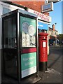
East Howe: postbox № BH10 142, Kinson Road
This postbox stands outside Image, although it may have been moved from outside the premises next door, which was a post office till the mid/late-1980s (see description of earlier link).
Image: © Chris Downer
Taken: 3 Jul 2008
0.11 miles
9
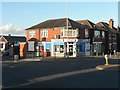
East Howe: Peter?s News
A newsagent at 335 Columbia Road, at its western end. The converted shopfront to the right, number 333, was East Howe Post Office, which closed on 19 June 1985. Also in the picture is Image
Image: © Chris Downer
Taken: 3 Jul 2008
0.11 miles
10
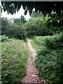
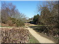
West Howe: footpath U22 heads into Fernheath Valley
This public footpath appears to be contrary to most similar ones in the borough, in that the course of the public right of way extends beyond the passageway and out into the open space of the nature reserve.
Its directly straight path is not possible due to intervening bushes, but this is the view along the trodden path that brings us out into Fernheath Valley. The extent of the route is probably to about halfway along the straight path ahead, where a turning to the right is hidden behind the ferns immediately in front of us.
See Image for the view behind us, to the emergence of the passageway onto the open space.
Image: © Chris Downer
Taken: 9 Jul 2016
0.11 miles