IMAGES TAKEN NEAR TO
Fernheath Road, BOURNEMOUTH, BH11 8SQ
Introduction
This page details the photographs taken nearby to Fernheath Road, BH11 8SQ by members of the Geograph project.
The Geograph project started in 2005 with the aim of publishing, organising and preserving representative images for every square kilometre of Great Britain, Ireland and the Isle of Man.

There are currently over 7.5m images from over14,400 individuals and you can help contribute to the project by visiting https://www.geograph.org.uk
Image Map (63 Images)


Getting Data...Please wait
Leaflet Map data © OpenStreetMap
Images are licensed for reuse under creativecommons.org/licenses/by-sa/2.0
Notes
- Clicking on the map will re-center to the selected point.
- The higher the marker number, the further away the image location is from the centre of the postcode.
Image Listing (63 Images Found)
Images are licensed for reuse under creativecommons.org/licenses/by-sa/2.0
Image
Details
Distance
1
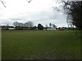
West Howe, sports ground
On Fernheath Road; pavilion to the right (East).
Image: © Mike Faherty
Taken: 21 Feb 2010
0.01 miles
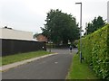
2
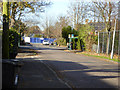
Fernheath Road
The bus stop is for service 5a towards Bournemouth town centre.
Image: © Robin Webster
Taken: 25 Nov 2016
0.02 miles
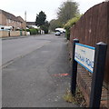
3
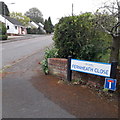
West Howe: Fernheath Close
A cul-de-sac of Fernheath Road, the latter being on the very fringe of the large West Howe council estate, unlike the bungalows here.
The sign is a modern one, from 2010-15 when this more modern, abstract emblem rather than the traditional town coat of arms as the working logo of the council. The no-through-road sign is an afterthought here, whereas it is often incorporated into the nameplate.
This is photo no.142 of a series of 453 in my coronavirus lockdown walking project:
See https://www.geograph.org.uk/article/My-2020-Coronavirus-Lockdown-walking-project for the complete set of photos.
Image: © Chris Downer
Taken: 18 Apr 2020
0.02 miles
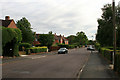
5
West Howe: Coleman Road
Coleman Road is on the southern side of the large 1950s West Howe council estate and comprises semi-detached houses readily recognisable as originally council houses.
The sign dates from around 2010-15 when this more modern, abstract emblem rather than the traditional town coat of arms as the working logo of the council.
This is photo no.74 of a series of 453 in my coronavirus lockdown walking project:
See https://www.geograph.org.uk/article/My-2020-Coronavirus-Lockdown-walking-project for the complete set of photos.
Image: © Chris Downer
Taken: 18 Apr 2020
0.04 miles
6
West Howe: vandalised postbox
A Royal Mail notice in the bottom of Image apologises for the fact that collections have been temporarily cancelled from this point, owing to circumstances totally beyond their control. It states that the last collection from here was on 27 November and gives details of three nearby alternative boxes.
It was subsequently replaced by a modern box – see Image
Image: © Chris Downer
Taken: 7 Dec 2008
0.06 miles
7
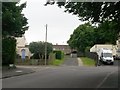
West Howe: footpath U03 from Maclean Road
Looking along the end of Coleman Road as it comes out onto Maclean Road (whose dead end is just a few yards to the left).
Ahead of us, a driveway to garages also acts as the start of the public footpath through to Turbary Park Avenue.
See Image for the view towards us from the top of the driveway, and links to further photos along the route of the footpath.
Image: © Chris Downer
Taken: 15 Jul 2016
0.07 miles
8
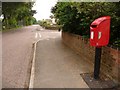
West Howe: replacement postbox in Fernheath Road
A little over six months after the George VI-reign Image became unusable owing to vandalism, it has now been replaced by a modern box on a pole.
See also Image
Image: © Chris Downer
Taken: 12 Jun 2009
0.07 miles
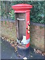
9

West Howe: postbox № BH11 285, Fernheath Road
The 5a bus travels past this George VI-reign postbox on Fernheath Road, at the southern edge of the large council housing estate of West Howe.
A few months later it would be vandalised and, eventually, replaced: see Image and Image
Image: © Chris Downer
Taken: 17 Aug 2008
0.07 miles
10
West Howe: footpath U03 approaches Maclean Road
The route of this public footpath follows the driveway to rear garage accesses at this northern end. We look along that segment of the path as it nears its destination on Maclean Road. Coleman Road faces us.
See Image for the view towards us from under the large tree, and Image for the next view on the path behind us, with links to further views along the route.
Image: © Chris Downer
Taken: 15 Jul 2016
0.08 miles