IMAGES TAKEN NEAR TO
Elliott Road, West Howe Industrial Estate, BOURNEMOUTH, BH11 8JJ
Introduction
This page details the photographs taken nearby to Elliott Road, West Howe Industrial Estate, BH11 8JJ by members of the Geograph project.
The Geograph project started in 2005 with the aim of publishing, organising and preserving representative images for every square kilometre of Great Britain, Ireland and the Isle of Man.

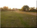
There are currently over 7.5m images from over14,400 individuals and you can help contribute to the project by visiting https://www.geograph.org.uk
Image Map (Loading...)


Getting Data...Please wait
Leaflet Map data © OpenStreetMap
Images are licensed for reuse under creativecommons.org/licenses/by-sa/2.0
Notes
- Clicking on the map will re-center to the selected point.
- The higher the marker number, the further away the image location is from the centre of the postcode.
Image Listing (46 Images Found)
Images are licensed for reuse under creativecommons.org/licenses/by-sa/2.0
Image
Details
Distance
1
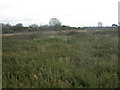
Old Plantation Heath, Turbary Common
The eastern end of Turbary Common is predominantly dry heathland, with gorse & bell heather.
http://www.english-nature.gov.uk/special/lnr/lnr_details.asp?ID=%20607
Image: © Mike Faherty
Taken: 8 Dec 2008
0.03 miles
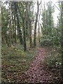
3
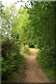
Path on the western edge of Turbary Common
Image: © David Lally
Taken: 1 Jul 2010
0.06 miles
4
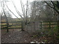
Kissing gate, Turbary Common
At the north-west entrance to the common; sturdy metal gate provided by Bournemouth Council
Image: © Mike Faherty
Taken: 8 Dec 2008
0.09 miles
5
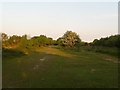
West Howe: western end of Turbary Common
Turbary Common is a vast (for the suburbs) nature reserve and here we are looking down the centre of the common from the western end.
Image: © Chris Downer
Taken: 11 May 2009
0.10 miles
6
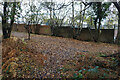
Pottery Woods, Turbary Common
Pottery Woods is a narrow strip of woodland, hemmed in by housing to the east & an industrial estate to the west, which leads to the common proper. It apparently used to be allotments; this would account for there being no mature trees.
Image: © Mike Faherty
Taken: 8 Dec 2008
0.10 miles
8
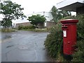
West Howe: postbox № BH11 111, Elliott Road
This postbox serves a medium-sized industrial estate on Elliott Road, a squareish road which has two access roads leading to it. The box is on the corner of one of these.
Image: © Chris Downer
Taken: 4 Jul 2008
0.12 miles
9
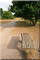
West Howe: clearing on Turbary Common
The path through the heathland widens here, and there is a small bench on the right.
Image: © Chris Downer
Taken: 11 May 2009
0.13 miles
10
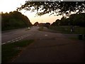
West Howe: Mandale Road meets Turbary Park Avenue
We look along the western end of Turbary Park Avenue, where Mandale Road comes out from the large council estate of West Howe. Apart from Turbary Park Avenue (which is named after Turbary Common alongside) and the other original thoroughfares, the roads on the West Howe estate are named after local heroes from the Second World War.
Image: © Chris Downer
Taken: 11 May 2009
0.13 miles