IMAGES TAKEN NEAR TO
Coleman Road, BOURNEMOUTH, BH11 8EH
Introduction
This page details the photographs taken nearby to Coleman Road, BH11 8EH by members of the Geograph project.
The Geograph project started in 2005 with the aim of publishing, organising and preserving representative images for every square kilometre of Great Britain, Ireland and the Isle of Man.

There are currently over 7.5m images from over14,400 individuals and you can help contribute to the project by visiting https://www.geograph.org.uk
Image Map (Loading...)


Getting Data...Please wait
Leaflet Map data © OpenStreetMap
Images are licensed for reuse under creativecommons.org/licenses/by-sa/2.0
Notes
- Clicking on the map will re-center to the selected point.
- The higher the marker number, the further away the image location is from the centre of the postcode.
Image Listing (69 Images Found)
Images are licensed for reuse under creativecommons.org/licenses/by-sa/2.0
Image
Details
Distance
1
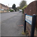
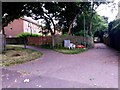
West Howe: Coleman Road
Coleman Road is on the southern side of the large 1950s West Howe council estate and comprises semi-detached houses readily recognisable as originally council houses.
The sign dates from around 2010-15 when this more modern, abstract emblem rather than the traditional town coat of arms as the working logo of the council.
This is photo no.74 of a series of 453 in my coronavirus lockdown walking project:
See https://www.geograph.org.uk/article/My-2020-Coronavirus-Lockdown-walking-project for the complete set of photos.
Image: © Chris Downer
Taken: 18 Apr 2020
0.01 miles
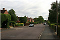
3
Fernheath Road
The bus stop is for service 5a towards Bournemouth town centre.
Image: © Robin Webster
Taken: 25 Nov 2016
0.04 miles
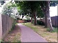
4
West Howe: footpath U03 from Maclean Road
Looking along the end of Coleman Road as it comes out onto Maclean Road (whose dead end is just a few yards to the left).
Ahead of us, a driveway to garages also acts as the start of the public footpath through to Turbary Park Avenue.
See Image for the view towards us from the top of the driveway, and links to further photos along the route of the footpath.
Image: © Chris Downer
Taken: 15 Jul 2016
0.05 miles
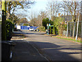
5
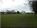
West Howe, sports ground
On Fernheath Road; pavilion to the right (East).
Image: © Mike Faherty
Taken: 21 Feb 2010
0.05 miles
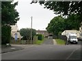
6
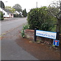
West Howe: Fernheath Close
A cul-de-sac of Fernheath Road, the latter being on the very fringe of the large West Howe council estate, unlike the bungalows here.
The sign is a modern one, from 2010-15 when this more modern, abstract emblem rather than the traditional town coat of arms as the working logo of the council. The no-through-road sign is an afterthought here, whereas it is often incorporated into the nameplate.
This is photo no.142 of a series of 453 in my coronavirus lockdown walking project:
See https://www.geograph.org.uk/article/My-2020-Coronavirus-Lockdown-walking-project for the complete set of photos.
Image: © Chris Downer
Taken: 18 Apr 2020
0.05 miles
7
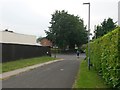
West Howe: footpath U03 approaches Maclean Road
The route of this public footpath follows the driveway to rear garage accesses at this northern end. We look along that segment of the path as it nears its destination on Maclean Road. Coleman Road faces us.
See Image for the view towards us from under the large tree, and Image for the next view on the path behind us, with links to further views along the route.
Image: © Chris Downer
Taken: 15 Jul 2016
0.05 miles
8
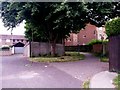
West Howe: footpath U03 goes straight on
Coming up the driveway at the end of Maclean Road, there is access to garages on our immediate left and, sharp right, a continuing rear driveway between the back gardens of houses on Maclean Road and Turbary Park Avenue.
Meanwhile, the public footpath continues straight ahead, through the trees to Turbary Park Avenue.
See Image for a similar view from just ahead of us, to see down the driveway, and Image for the arrival at Maclean Road behind us.
Image: © Chris Downer
Taken: 15 Jul 2016
0.07 miles
9
West Howe: a rear driveway and footpath U03 part company
This public footpath, from Maclean Road, has been the pavement (behind us) of the access to the garage driveway. The driveway swings to the right, to head along the backs of the houses, while the footpath continues ahead to Turbary Park Avenue.
See Image for a wider view from slightly behind us, and Image for the next view on the path ahead - each giving links to further views along the route.
Incidentally, the driveway ahead is the same one that forms part of another public footpath between the same two roads - see Image
Image: © Chris Downer
Taken: 15 Jul 2016
0.08 miles
10
West Howe: footpath U03 heads for Maclean Road
This public footpath leads from Turbary Park Avenue behind us, to Maclean Road, which is not the carriageway in the background - the path crosses a rear driveway and follows its access out onto Maclean Road.
See Image for the view towards us from by the driveway ahead, with links to further photos down the length of the path, and Image for the view of the start of the path behind us.
Image: © Chris Downer
Taken: 15 Jul 2016
0.08 miles