IMAGES TAKEN NEAR TO
Cunningham Crescent, BOURNEMOUTH, BH11 8DP
Introduction
This page details the photographs taken nearby to Cunningham Crescent, BH11 8DP by members of the Geograph project.
The Geograph project started in 2005 with the aim of publishing, organising and preserving representative images for every square kilometre of Great Britain, Ireland and the Isle of Man.

There are currently over 7.5m images from over14,400 individuals and you can help contribute to the project by visiting https://www.geograph.org.uk
Image Map
Images are licensed for reuse under creativecommons.org/licenses/by-sa/2.0
Notes
- Clicking on the map will re-center to the selected point.
- The higher the marker number, the further away the image location is from the centre of the postcode.
Image Listing (85 Images Found)
Images are licensed for reuse under creativecommons.org/licenses/by-sa/2.0
Image
Details
Distance
1
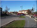
Bournemouth : Cunningham Crescent
A Wilts&Dorset bus is seen here exiting from Montgomery Avenue.
Image: © Lewis Clarke
Taken: 8 Mar 2010
0.01 miles
2
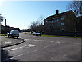
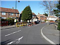
Bournemouth : Cunningham Crescent Junction
A road junction from Tedder Road into Cunningham Crescent.
Image: © Lewis Clarke
Taken: 8 Mar 2010
0.01 miles
3
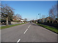
Bournemouth : Montgomery Avenue
If you follow this road all the way from here at Cunningham Crescent, to the end, you'll end up on Kinson Road.
Image: © Lewis Clarke
Taken: 8 Mar 2010
0.02 miles
4
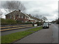
West Howe, Montgomery Avenue
1960s-looking houses on the eastern side of West Howe Estate.
Image: © Mike Faherty
Taken: 21 Feb 2010
0.03 miles
5
Bournemouth : Gort Road & Roadworks
These workmen are busy and they have some lovely weather to help them work.
Image: © Lewis Clarke
Taken: 8 Mar 2010
0.05 miles
6
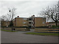
West Howe, flats
1960s-looking flats on Cunningham Crescent, in the centre of West Howe Estate.
Image: © Mike Faherty
Taken: 21 Feb 2010
0.06 miles
7
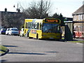
Bournemouth : Cunningham Crescent Bus Stop
The 5b bus picks up some passengers. Soon after this photograph I was approached by two teenage girls who wanted a fag and wondered if I had any.
Image: © Lewis Clarke
Taken: 8 Mar 2010
0.06 miles
8
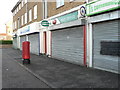
West Howe: Cunningham Crescent Post Office
Cunningham Crescent is a circular road at the hub of the large West Howe council estate. The parade of shops here also includes pharmacy (in the background), convenience store and fish & chip shop.
Image: © Chris Downer
Taken: 23 Nov 2008
0.07 miles
9
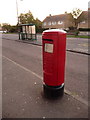
West Howe: postbox № BH11 308, Cunningham Crescent
This modern 'Type K' postbox stands outside Image and is emptied finally at 5:30pm on weekdays and at 12:30pm on Saturdays.
Image: © Chris Downer
Taken: 15 Jun 2010
0.07 miles
10
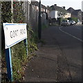
West Howe: Gort Road
A short, squiggly road in the heart of the large 1950s West Howe council estate – it comes off the centrepiece, Cunningham Crescent, although we are looking at it from the other end, on Mount Road.
The sign is of a design that became prevalent in Bournemouth around 1990 and was in use for most of that decade. Many are starting to look a bit shabby now, the blue border fading and the white surface unpeeling, but this one is in pretty good condition.
This is photo no.169 of a series of 453 in my coronavirus lockdown walking project:
See https://www.geograph.org.uk/article/My-2020-Coronavirus-Lockdown-walking-project for the complete set of photos.
Image: © Chris Downer
Taken: 12 Apr 2020
0.08 miles