IMAGES TAKEN NEAR TO
Verney Close, BOURNEMOUTH, BH11 8DD
Introduction
This page details the photographs taken nearby to Verney Close, BH11 8DD by members of the Geograph project.
The Geograph project started in 2005 with the aim of publishing, organising and preserving representative images for every square kilometre of Great Britain, Ireland and the Isle of Man.

There are currently over 7.5m images from over14,400 individuals and you can help contribute to the project by visiting https://www.geograph.org.uk
Image Map (Loading...)


Getting Data...Please wait
Leaflet Map data © OpenStreetMap
Images are licensed for reuse under creativecommons.org/licenses/by-sa/2.0
Notes
- Clicking on the map will re-center to the selected point.
- The higher the marker number, the further away the image location is from the centre of the postcode.
Image Listing (84 Images Found)
Images are licensed for reuse under creativecommons.org/licenses/by-sa/2.0
Image
Details
Distance
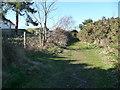
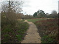
1
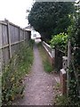
West Howe: arriving on Verney Close on footpath U22
The public footpath from Fernheath Valley nature reserve approaches the dead end of Verney Close, ahead. The last house around the dead-end has a gate onto the path.
See Image for the view towards us from the road, and Image for the next view behind us.
Image: © Chris Downer
Taken: 9 Jul 2016
0.03 miles
2
West Howe: footpath U22 from Verney Close
A grass/gravel public footpath leading into Fernheath Valley local nature reserve.
See Image for the view towards us from down the path.
Image: © Chris Downer
Taken: 9 Jul 2016
0.03 miles
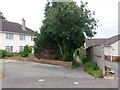
3

West Howe: Moorside Gardens
Modern infill development of a few houses, off Moorside Road. Because the houses are tucked around the back of the two adjoining gardens, we can't see any of them from here at the end of the road.
The sign is a modern one, from 2010-15 when this more modern, abstract emblem rather than the traditional town coat of arms as the working logo of the council. It is unusual in being a short version with the road name on two lines.
This is photo no.282 of a series of 453 in my coronavirus lockdown walking project:
See https://www.geograph.org.uk/article/My-2020-Coronavirus-Lockdown-walking-project for the complete set of photos.
Image: © Chris Downer
Taken: 11 Apr 2020
0.04 miles
4
West Howe: approaching footpath U22 from Fernheath Valley
The public footpath from Verney Close emerges onto the Fernheath Valley nature reserve and common. Contrary to most similar paths in the borough, course of the public right of way appears to extend beyond the passageway and out into the open space a little way behind us.
Its directly straight path is not possible due to the bushes on the left, but see Image for the continuing path behind us.
See Image for the view down the path towards here.
Image: © Chris Downer
Taken: 9 Jul 2016
0.05 miles
5
West Howe: footpath U22 heads for Fernheath Valley
The public footpath comes down from Verney Road and enters the Fernheath Valley local nature reserve.
See Image for its emergence onto the common ahead, and Image for the view behind us up the path.
Image: © Chris Downer
Taken: 9 Jul 2016
0.05 miles
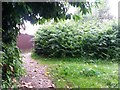
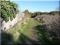
6
Bournemouth : Grassy Path, Fernheath Valley
A small path which backs onto houses from Verney Close.
Image: © Lewis Clarke
Taken: 8 Mar 2010
0.06 miles
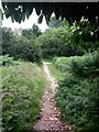
7
Bournemouth : Footpath at Fernheath Valley
A path which runs alongside the backs of houses on Moorside Road.
Image: © Lewis Clarke
Taken: 8 Mar 2010
0.07 miles
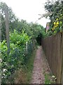
8
West Howe: footpath U22 heads into Fernheath Valley
This public footpath appears to be contrary to most similar ones in the borough, in that the course of the public right of way extends beyond the passageway and out into the open space of the nature reserve.
Its directly straight path is not possible due to intervening bushes, but this is the view along the trodden path that brings us out into Fernheath Valley. The extent of the route is probably to about halfway along the straight path ahead, where a turning to the right is hidden behind the ferns immediately in front of us.
See Image for the view behind us, to the emergence of the passageway onto the open space.
Image: © Chris Downer
Taken: 9 Jul 2016
0.07 miles
9
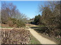
Bournemouth : Fernheath Valley & Footpath
A footpath along Turbary Common near Kinson and West Howe.
Image: © Lewis Clarke
Taken: 8 Mar 2010
0.07 miles
10
Fernheath Valley, Turbary Common
Fernheath Valley is a detached part of Turbary Common Nature Reserve; a narrow belt of open land along a wooded stream (probably the same as in Image), with small patches of heathland.
Image: © Mike Faherty
Taken: 8 Dec 2008
0.08 miles