IMAGES TAKEN NEAR TO
Verney Road, BOURNEMOUTH, BH11 8BZ
Introduction
This page details the photographs taken nearby to Verney Road, BH11 8BZ by members of the Geograph project.
The Geograph project started in 2005 with the aim of publishing, organising and preserving representative images for every square kilometre of Great Britain, Ireland and the Isle of Man.

There are currently over 7.5m images from over14,400 individuals and you can help contribute to the project by visiting https://www.geograph.org.uk
Image Map (Loading...)


Getting Data...Please wait
Leaflet Map data © OpenStreetMap
Images are licensed for reuse under creativecommons.org/licenses/by-sa/2.0
Notes
- Clicking on the map will re-center to the selected point.
- The higher the marker number, the further away the image location is from the centre of the postcode.
Image Listing (67 Images Found)
Images are licensed for reuse under creativecommons.org/licenses/by-sa/2.0
Image
Details
Distance
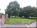
1
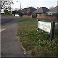
West Howe: Fernheath Road
Seen here coming off Turbary Park Avenue, Fernheath Road is one of the main access roads to the large West Howe council estate, especially via Verney Road which is next on the right, virtually in the picture. The bungalows at this southeast end give way to council semi-detached houses midway along.
The road sign is a standard one from around 2000-2006, perhaps a little earlier, featuring the borough coat of arms.
This is photo no.143 of a series of 453 in my coronavirus lockdown walking project:
See https://www.geograph.org.uk/article/My-2020-Coronavirus-Lockdown-walking-project for the complete set of photos.
Image: © Chris Downer
Taken: 12 Apr 2020
0.05 miles
2
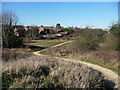
Fernheath Valley, Turbary Common
Fernheath Valley is a detached part of Turbary Common Nature Reserve; a narrow belt of open land along a wooded stream (probably the same as in Image), with small patches of heathland.
Image: © Mike Faherty
Taken: 8 Dec 2008
0.07 miles
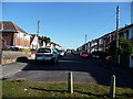
3
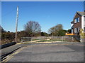
Bournemouth : Acres Road
Acres Road doesn't go anywhere, it is just a residential close off Kinson Road.
Image: © Lewis Clarke
Taken: 8 Mar 2010
0.07 miles
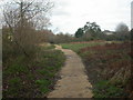
4
Bournemouth : Turbary Common & Path
At the bottom of Acres Road you come to this path which heads towards Turbary Park Avenue.
Image: © Lewis Clarke
Taken: 8 Mar 2010
0.08 miles
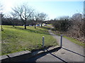
5
West Howe: footpath U21 from Acres Road
This public footpath is undefined by tarmac, gravel or whatever and simply follows the edge of the broad green space around Turbary Park Avenue, at the top of Fernheath Valley. There is, however, a paved path heading to the right, to the start of Fernheath Road.
See Image for a view towards us from midway along the path ahead, and Image for a wider view from behind us.
Image: © Chris Downer
Taken: 9 Jul 2016
0.08 miles
6
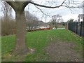
East Howe: passing a tree on footpath U21
The course of this short public footpath is unsurfaced along this eastern edge of the grass, although a paved route is available running diagonally to the left and visible in the picture. It is just a short path - to Acres Road which we see ahead, from Turbary Park Avenue which is slightly less distance behind us.
See Image for the view towards us from the road ahead, and Image for the view from Turbary Park Avenue, behind us.
Image: © Chris Downer
Taken: 18 Mar 2017
0.08 miles
7
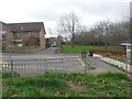
East Howe: across the dead end of Acres Road
We look out of the Fernheath Valley local nature reserve onto the dead end of Acres Road. Ahead of us, a public footpath (number U21) takes an undefined course across the grass, alongside the wall to reach Turbary Park Avenue, which is all but visible in the background.
See Image for a similar view from just ahead.
Image: © Chris Downer
Taken: 18 Mar 2017
0.08 miles
8
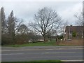
East Howe: footpath U21 from Turbary Park Avenue
Looking across Turbary Park Avenue, directly along the course of a public footpath which unusually is not marked out by tarmac or any sort of paving. It runs along the edge of the grassed area onto the dead end of Acres Road, which can be seen in the background.
See Image for the next view along the path, just by the prominent tree.
Image: © Chris Downer
Taken: 18 Mar 2017
0.08 miles
9
Bournemouth : Fernheath Valley
Fernheath Valley is part of - but detached from - Turbary Common.
Image: © Lewis Clarke
Taken: 8 Mar 2010
0.09 miles
10
Bournemouth : Cherford Road
Another road leading to a close is Cherford Road, which heads back towards Kinson Road.
Image: © Lewis Clarke
Taken: 8 Mar 2010
0.09 miles