IMAGES TAKEN NEAR TO
Rodwell Close, BOURNEMOUTH, BH10 7JH
Introduction
This page details the photographs taken nearby to Rodwell Close, BH10 7JH by members of the Geograph project.
The Geograph project started in 2005 with the aim of publishing, organising and preserving representative images for every square kilometre of Great Britain, Ireland and the Isle of Man.

There are currently over 7.5m images from over14,400 individuals and you can help contribute to the project by visiting https://www.geograph.org.uk
Image Map
Images are licensed for reuse under creativecommons.org/licenses/by-sa/2.0
Notes
- Clicking on the map will re-center to the selected point.
- The higher the marker number, the further away the image location is from the centre of the postcode.
Image Listing (97 Images Found)
Images are licensed for reuse under creativecommons.org/licenses/by-sa/2.0
Image
Details
Distance
1
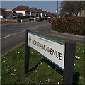
Kinson: Horsham Avenue
Quite an important side-street of Kinson, the main one leading to the residential roads to the north of the shopping centre.
The road sign is a standard one from around 2000-2006, perhaps a little earlier, featuring the borough coat of arms.
This is photo no.205 of a series of 453 in my coronavirus lockdown walking project:
See https://www.geograph.org.uk/article/My-2020-Coronavirus-Lockdown-walking-project for the complete set of photos.
Image: © Chris Downer
Taken: 10 Apr 2020
0.09 miles
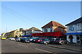
2

Kinson: postbox № BH10 375, Horsham Avenue
Looking down the southern end of Horsham Avenue, towards the main shopping street in Kinson, Wimborne Road. The postbox is a large one.
Image: © Chris Downer
Taken: 21 Jul 2008
0.10 miles
4
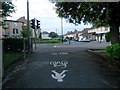
Kinson: footpath E49 arrives on Wimborne Road
This public footpath, from Leybourne Avenue and Howton Road, arrives at its northern end on the main Wimborne Road. Kinson Grove is opposite.
The pedestrian crossing, just to the left of the path's emergence, was installed in the last year or so.
It appears that this northern segment of the path has been made a shared foot/cycle path.
See Image for the path behind us.
Image: © Chris Downer
Taken: 24 Jun 2016
0.11 miles
6
Kinson: footpath E49 crosses the Conservative Club car park
This public footpath heads from Wimborne Road to Howton Road and Leybourne Avenue, and almost immediately crosses the car park access within the Conservative Club grounds. I have a feeling that the Club has only acquired the car park in relatively recent years, as it has a fairly large frontage car park anyway.
See Image for the start of the path behind us, and Image for the next picture ahead.
Image: © Chris Downer
Taken: 24 Jun 2016
0.12 miles
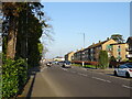
7
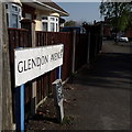
Kinson: Glendon Avenue
The bungalows on the left and the houses on the right are all quite desirable properties, typifying this part of Kinson north of Wimborne Road.
The sign is of a design that became prevalent in Bournemouth around 1990 and was in use for most of that decade. Many are starting to look a bit shabby now, and the blue border has faded almost to nothing on this one, with the white surface peeled off around the edges.
This is photo no.162 of a series of 453 in my coronavirus lockdown walking project:
See https://www.geograph.org.uk/article/My-2020-Coronavirus-Lockdown-walking-project for the complete set of photos.
Image: © Chris Downer
Taken: 10 Apr 2020
0.12 miles
8
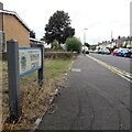
Kinson: Kinson Grove
Kinson Grove forms three sides of a largeish rectangle off Wimborne Road, with the resultant two 90º corners at the far end.
Here we look along it from the eastern end, with the telephone exchange on the corner.
The road sign is a standard one from around 2000-2006, perhaps a little earlier, featuring the borough coat of arms.
This is photo no.230 of a series of 453 in my coronavirus lockdown walking project:
See https://www.geograph.org.uk/article/My-2020-Coronavirus-Lockdown-walking-project for the complete set of photos.
Image: © Chris Downer
Taken: 10 Apr 2020
0.13 miles
9
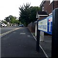
Kinson: Kitscroft Road
At the eastern end of Kinson's main shops is Kitscroft Road, a short cul-de-sac which leads to several other roads, all of whose only access is via here. From satellite images, the little development looks almost unfinished, with a number of rather abrupt dead ends that look as if there was once an intention that development go further. At the end of Kitscroft Road, there is access onto Duke's Coppice and that small detached part of Kinson Common, which remains public open space.
The sign is a modern one, from 2010-15 when this more modern, abstract emblem rather than the traditional town coat of arms as the working logo of the council. The no-through-road sign incorporated into the nameplate is a common arrangement.
This is photo no.233 of a series of 453 in my coronavirus lockdown walking project:
See https://www.geograph.org.uk/article/My-2020-Coronavirus-Lockdown-walking-project for the complete set of photos.
Image: © Chris Downer
Taken: 10 Apr 2020
0.13 miles
10
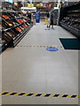
Kinson: social distancing in the fruit and veg aisle
A trip to the supermarket was a very different experience during the spring of 2020, when the global coronavirus pandemic led to a 'lockdown', with only essential journeys allowed and social distancing being required – this means that one must keep 2m apart from other people.
Tesco, along with all retail outlets that were allowed to remain open during the pandemic, took reasonable measures to ensure that its staff and customers adhere to social distancing. Numbers of shoppers in the store at any one time were restricted, and the aisles and outside areas marked with tape at 2m intervals.
Here, we have just entered the store (Image) and are in the fresh veg aisle. As can be seen here, the tape indicates the 2m intervals and the second blue sign shows that the aisle has been made a one-way street so that shoppers will not have to pass in each direction.
The whole situation seemed to be being taken seriously and in good spirits by staff and customers alike. The store was well stocked, at 4:50 in the afternoon, a far cry from the shortages of everyday goods caused by panic buying in the last couple of weeks. There were no eggs or pasta, but other goods that were difficult to find last week – milk, bread, and particularly toilet rolls – were readily available today.
See Image for a view of our entry into the store just now, and Image for the wait for a checkout.
Image: © Chris Downer
Taken: 4 Apr 2020
0.13 miles