IMAGES TAKEN NEAR TO
Old Vicarage Close, BOURNEMOUTH, BH10 7DU
Introduction
This page details the photographs taken nearby to Old Vicarage Close, BH10 7DU by members of the Geograph project.
The Geograph project started in 2005 with the aim of publishing, organising and preserving representative images for every square kilometre of Great Britain, Ireland and the Isle of Man.

There are currently over 7.5m images from over14,400 individuals and you can help contribute to the project by visiting https://www.geograph.org.uk
Image Map
Images are licensed for reuse under creativecommons.org/licenses/by-sa/2.0
Notes
- Clicking on the map will re-center to the selected point.
- The higher the marker number, the further away the image location is from the centre of the postcode.
Image Listing (46 Images Found)
Images are licensed for reuse under creativecommons.org/licenses/by-sa/2.0
Image
Details
Distance
1
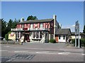
Toby Carvery, Ensbury
This public house and restaurant is close to the Northbourne Roundabout at Ensbury.
Image: © mike smith
Taken: 1 Aug 2007
0.04 miles
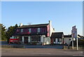
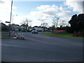
2
Bournemouth : New Road & Northbourne Roundabout
A sign with directions, and behind it, another sign welcoming you to Bournemouth.
Image: © Lewis Clarke
Taken: 11 Feb 2010
0.04 miles
3
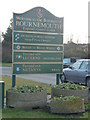
Bournemouth : Welcome to Bournemouth Sign
All the information about who the town is twinned with, and a few little pots as well.
Image: © Lewis Clarke
Taken: 11 Feb 2010
0.05 miles
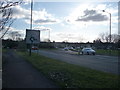
5
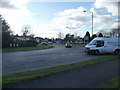
Bournemouth : Northbourne Roundabout
Northbourne Roundabout has roads off to Whitelegg Way, Wimborne Road and New Road.
Image: © Lewis Clarke
Taken: 11 Feb 2010
0.06 miles
6
Bournemouth : Stour Park
Stour Park is a holiday campsite in the Northbourne area of Bournemouth.
Image: © Lewis Clarke
Taken: 11 Feb 2010
0.07 miles
7
Bournemouth : New Road
Cars travel into the heart of Bournemouth from Ferndown on this road.
Image: © Lewis Clarke
Taken: 11 Feb 2010
0.08 miles
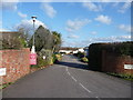
8
Northbourne: footpath O22 emerges onto Wimborne Road
This public footpath leads from Northbourne Gardens to Wimborne Road, ahead of us. Its second half is a driveway access to 1260 Wimborne Road, which is just to our right, behind 1258 which is on the corner ahead.
See Image for the view behind us to the more 'path-like' footpath, and Image] for a view here from the path itself.
Image: © Chris Downer
Taken: 22 Jun 2016
0.08 miles
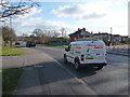
9
Bournemouth : Northbourne Roundabout
Ensbury Garage and Tesco Express can be seen in the background.
Image: © Lewis Clarke
Taken: 11 Feb 2010
0.08 miles
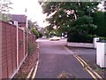
10

Ensbury Garage
This vehicle repair establishment has been there for several decades. As can be seen, the immediate area is always chocker-block with cars.
Image: © mike smith
Taken: 1 Aug 2007
0.09 miles